Taiwan's Yunlin County Reveals Diverse Farming Patterns in New NASA Satellite Imagery
NASA Earth Observatory imagery captures the contrast between modern specialty crops protected by shade nets and historical sugarcane fields near Baozhong, highlighting a region where less than one hectare per farm supports millions of pigs and billions of dollars in annual output.
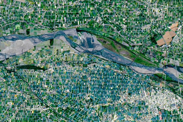
NASA Earth Observatory imagery has characterised the agricultural landscape of Yunlin County in southwestern Taiwan as a vibrant mosaic of small-scale farms. Situated on the fertile Chianan Plain, the region produces a wide array of crops including rice, sweet potatoes, peanuts, corn, sugarcane, and leafy greens. Despite the average farm size being less than one hectare, the area supports millions of pigs and contributes significantly to the island's economy.
Taiwan's total agricultural output is valued at approximately $18 billion annually, a remarkable figure given that only about one-quarter of the island's land is arable due to mountainous terrain. The Chianan Plain, located on the southwestern side of the Pacific island, provides the necessary flat land and fertile soils to sustain this production. This intensive use of limited space results in 0.03 hectares of farmland per Taiwanese citizen, a figure that contrasts sharply with significantly larger averages in the United Kingdom and the United States.
The satellite imagery reveals distinctive farming patterns that tell a story of both modern adaptation and historical legacy. Around Xiluo, fields take on an unusual greenish-blue hue caused by the ubiquity of shade nets. Farmers deploy these nets to protect specialty crops from heat, sun, heavy rains, and pests, creating a visual contrast with the darker green regions where rice is the dominant crop.
In the farmland north of Baozhong, the image displays large rectangular plots that persist as a legacy of expansive sugarcane plantations established during the early 1900s under Japanese colonial rule. These plantations were consolidated into the Taiwan Sugar Corporation after World War II, and the large plot sizes remain a remnant of that period. Although the amount of sugarcane cultivated has declined in recent decades, the Taiwan Sugar Corporation still raises sugarcane around Baozhong.
The agricultural infrastructure in the region also reflects this history. The company operates a railway that transports harvested cane to nearby Huwei, site of one of the few remaining sugar refineries on the island. While Taiwan once had a large network of sugar railways servicing thousands of kilometers of track, the line that serves Huwei is currently the only one on the island that remains active.
The small plot sizes observed across the county are partly a result of past government policies that limited farm size and partly a byproduct of cultural traditions. These traditions often lead to the division of farms into smaller parcels as property is passed from one generation to the next, shaping the intricate patchwork visible in the satellite data.


