NASA satellite data refines air quality forecasts for Northeast US during 2026 heat wave
New data from NASA’s Tropospheric Emissions: Monitoring of Pollution mission helped authorities issue timely health advisories for 35 million residents during a mid-May 2026 ozone event.
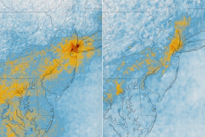
NASA’s TEMPO mission provided critical hourly air quality data along the New York–Washington corridor during a mid-May 2026 heat wave. By monitoring morning nitrogen dioxide and afternoon ozone levels, the mission supported health advisories issued by New York authorities, aiding forecasts for the region’s 35 million residents.
A mid-May heat wave in 2026 prompted the New York State Department of Health and the New York Department of Environmental Conservation to issue a code orange health advisory on May 17. Ground-based sensors confirmed ozone reached unhealthy levels for sensitive groups on May 18. TEMPO data showed high nitrogen dioxide concentrations during the early morning commute (7:05 a.m.) which dropped sharply by late afternoon (3:05 p.m.) as ozone increased.
On May 19, lidar data indicated a layer of ozone descending from above 5 kilometres, suggesting some ozone detected by TEMPO originated in the stratosphere. Another health advisory was issued by New York authorities on June 6. TEMPO provides hourly data, a significant improvement over previous polar-orbiting satellites that sampled once per day.
More than 35 million people live along the New York–Washington corridor. Air quality has improved significantly in recent decades, but ground-level ozone outbreaks remain common in warm summer months. Ozone formation is accelerated by chemical reactions involving nitrogen dioxide, volatile organic compounds, and oxygen, fueled by sunlight. Stratospheric ozone can occasionally be transported downward into the troposphere, affecting surface air quality.
TEMPO is located in geostationary orbit 22,000 miles (35,000 kilometres) above the equator. Previous sensors included OMI (Ozone Monitoring Instrument) and TROPOMI (Tropospheric Monitoring Instrument). Hazem Mahmoud is an atmospheric scientist at NASA’s Atmospheric Science Data Center at Langley Research Center. Data is available via NASA's Worldview browser, a Harvard & Smithsonian Center for Astrophysics tool, and NASA's Earthdata portal.