Curiosity rover uncovers hidden Martian geology after drive to 'smooth' terrain
NASA’s Curiosity rover encountered unexpected polygons, veins, and lamination on Mars, prompting a detailed imaging campaign to understand the area’s geological history.
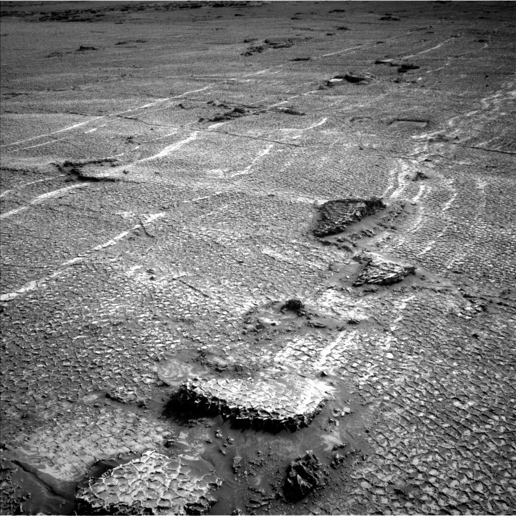
NASA’s Curiosity rover recently discovered unexpected fine-scale geological features on the Martian surface after driving to an area that appeared smooth in orbital and distant navigation images. The terrain, located near the base of the Cordillera outcrop, was found to be covered in polygons, veins, and lamination upon close inspection, with features measuring only a few centimetres across.
The discovery occurred during Sols 4927–4933, corresponding to the Earth planning date of Thursday, June 18, 2026. The rover drove approximately 35 metres to the target site, which geomorphologists had identified as smooth in pre-drive imagery. The science team intended to deploy the Drill Rotation Tool (DRT) at a bedrock target named Rio Baker, but the terrain proved too spiky for deployment. Despite this, the Alpha Particle X-ray Spectrometer (APXS) successfully analysed the Rio Baker target, while the Mastcam High Resolution Imaging Science Experiment (MAHLI) documented it.
Susanne P. Schwenzer, Professor of Planetary Mineralogy at The Open University in the UK, detailed the events in a blog post for the NASA Mars Science Laboratory Mission Team. She noted that while drive planning typically combines orbital geomorphology maps with ground-based drive direction imaging taken by the Mast Camera, the resolution from a distance was insufficient to reveal the tiny structures. The features were only visible in the high-resolution close-up images taken after the rover arrived.
Following the drive, the science team initiated an extensive imaging campaign to investigate the geologic history of the area. Plans include Mastcam panoramas using both its lower-resolution left eye and higher-resolution right eye, as well as ChemCam Remote Micro Imager images to document structures further afield. ChemCam will also use its Laser-Induced Breakdown Spectroscope (LIBS) to analyse three specific targets: Rio Chimore, a lighter-toned band; Rio de Lava, a vein target; and Rio de Salta, one of the identified polygons.
The APXS instrument is scheduled to examine additional bedrock and ridges at targets named Pampa Grande and Iquique Ridge, while MAHLI will provide close-up hand-lens imagery. The team also continues routine environmental observations, including monitoring dust devils, atmospheric opacity, pressure, and temperature. Schwenzer highlighted that the rover had also driven up a hill along terrain that looked smooth from a distance but was littered with tiny polygons, suggesting further surprises may lie ahead for the mission.