Smoke Blankets Oregon as Wildfires Burn Over One Million Acres
State officials invoke emergency powers and deploy 10,000 firefighters as drought conditions fuel rapid fire spread across central and eastern Oregon.
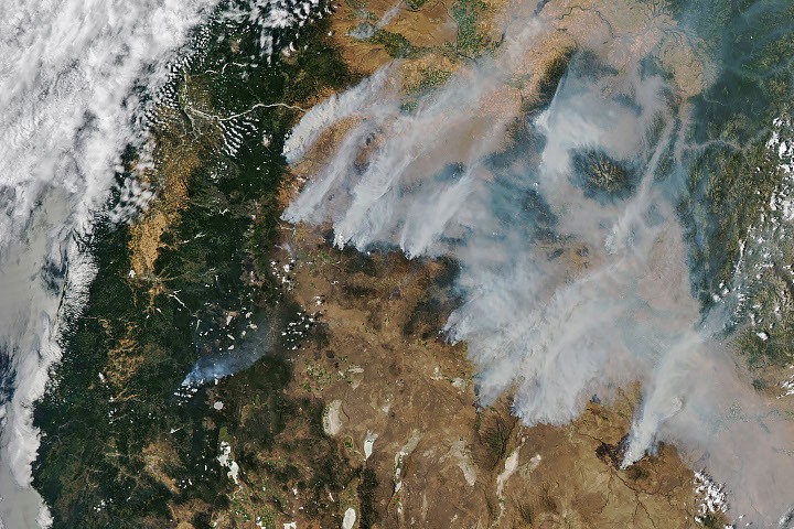
Lightning storms ignited dozens of wildfires across central and eastern Oregon in July 2026, creating a significant smoke haze that has prompted air quality advisories and evacuation orders. The crisis began on the evening of July 15, when dry thunderstorms over the Cascade Range produced thousands of lightning strikes as they moved east across the states. By the following day, NASA satellites had begun detecting large numbers of wildland fires burning throughout the region.
Although the initial blazes were small, they strengthened rapidly as they were fanned by gusty winds. The fires raced through landscapes parched by extreme drought and baking in summer heat, leading to widespread destruction. When NASA’s Aqua satellite captured imagery on the afternoon of July 26, smoke poured northeast from dozens of large fires that had collectively charred hundreds of square miles.
The largest active fires as of July 26 included the Hay Creek Complex, Brewer, Big Grass, Akawa Butte, and Powder River fires. According to the National Interagency Fire Center, several of these major blazes were less than 5 percent contained. State officials invoked Oregon’s Emergency Conflagration Act to protect communities from particularly threatening fires, specifically targeting the Shingle, Bench, Beachcomb, and Second Flat fires.
More than 10,000 firefighters were deployed to combat the blazes throughout the state. As of July 27, 2026, fires in Oregon had burned more than one million acres. The smoke produced by these fires created a blanket of haze, leading to air quality advisories for eastern Oregon and forcing many communities to issue evacuation orders.
On a national scale, the National Interagency Fire Center reported that fires had burned more than 4 million acres across the United States by late July. This figure exceeds the 10-year average for this point in the season, which stands at 3.4 million acres based on data from 2016 to 2025. Government satellite data, including MODIS data from NASA EOSDIS LANCE and GIBS/Worldview, are part of a global system of observations used to track fire behaviour and analyse emerging trends.
NASA makes real-time wildfire monitoring tools available to the public, including FIRMS (Fire Information for Resource Management System), the Worldview browser, and the Fire Event Explorer. These tools allow observers to track the progression of events such as the current Oregon crisis. The Earth Observatory image capturing the smoke blanket was created by Michala Garrison using the aforementioned MODIS data.