Mexico City Subsidence Accelerates: NISAR Satellite Maps Reveal Up to 2cm Monthly Sink Rates
Preliminary measurements between October 2025 and January 2026 point to intense groundwater pumping and urban compaction as drivers of the phenomenon threatening Benito Juarez International Airport and surrounding structures.
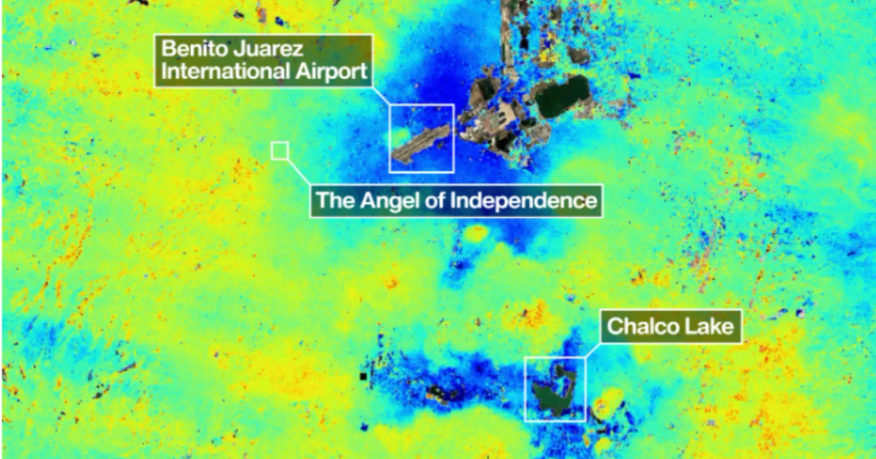
A new map generated by the NASA-ISRO Synthetic Aperture Radar (NISAR) satellite reveals that Mexico City is sinking unevenly, with specific areas registering subsidence rates of up to 2 centimetres per month. This data, derived from preliminary measurements taken between October 2025 and January 2026, underscores the accelerating nature of the phenomenon affecting one of the world's fastest-sinking cities. The findings serve as a stark reminder of the silent threat facing nearly 20 million residents and the critical infrastructure built upon the ancient bed of Lake Texcoco.
The agency specifies that the areas marked in dark blue on the new map correspond to subsidence exceeding 2 centimetres per month, a rate significantly higher than historical averages in some contexts but consistent with the differential nature of the sinking. Preliminary analysis indicates that this rapid ground movement is driven by intense groundwater pumping and the compaction of the ancient lake bed due to urban development. Both factors have caused the soil to compact over more than a century, a process first documented in 1925 by engineer Roberto Gayol.
The data highlights significant risks to critical infrastructure, specifically flagging Benito Juarez International Airport, located near Lake Nabor Carrillo, as operating within an area of accelerated subsidence. When a street, railway, or building sinks differently at one end compared to the other, its stability is compromised. This creates what is termed 'differential subsidence', where ground levels drop unevenly across small scales, potentially fracturing roads, buildings, and water lines over time.
The NISAR satellite, which became operational in July 2025, has captured the magnitude and evolution of this subsidence with unprecedented precision. As the first satellite to incorporate two synthetic aperture radars at different wavelengths, it allows for monitoring Earth's land surfaces twice every 12 days. This technological capability overcomes previous limitations such as cloud cover and dense vegetation, providing a clearer picture of terrain variations that optical sensors often miss.
A study conducted in 2024 by Dario Solano-Rojas, a remote-sensing specialist at the National Autonomous University of Mexico, supported these findings by concluding that subsidence rates are highly variable across the city. While some areas register drops of nearly 35 centimetres per year, others show almost imperceptible movement. This variability confirms that the ground is not sinking uniformly, posing specific structural challenges that require accurate and continuous monitoring for effective public policy and mitigation strategies.
NASA has demonstrated that its technology can play a key role in tracking these changes in near real time from orbit. Project manager David Bekaert noted that while Mexico City is a well-known hot spot for subsidence, images like this are just the beginning for NISAR. The agency expects an influx of new discoveries from all over the world, given the unique sensing capabilities of the satellite and its consistent global coverage.