Deep-focus tremor registers intensity 5 strong in central Hokkaido; no tsunami threat
Authorities rule out coastal danger following early morning quake, while broader regional seismic alerts remain active
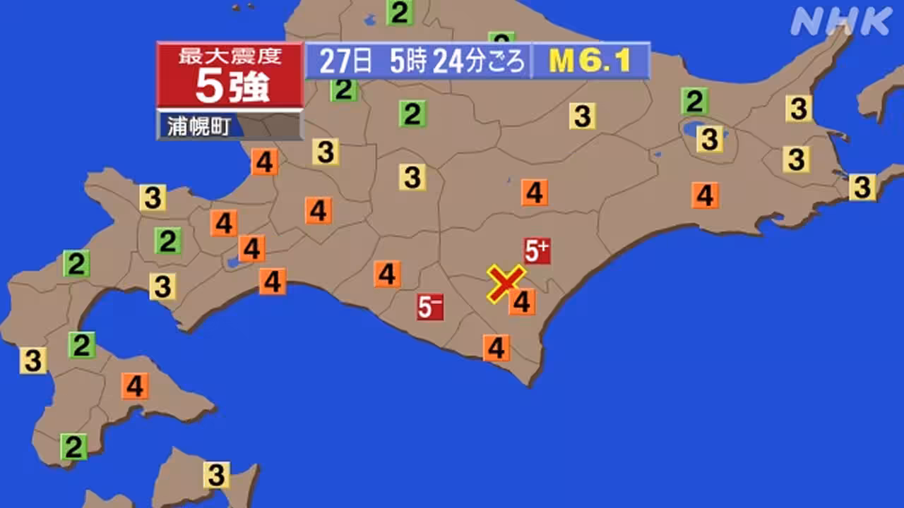
A magnitude 6.1 earthquake struck the southern part of central Hokkaido at approximately 05:24 on 27 April 2026, prompting immediate updates from the Japan Meteorological Agency. The official report locates the epicentre in the southern Kushiro region, noting a focal depth of 80 kilometres. This significant depth classifies the event as a deep-focus tremor, which typically generates less surface shaking than shallower quakes of comparable magnitude but still warrants monitoring for structural impacts.
The Japan Meteorological Agency assessed the maximum seismic intensity at 5 strong across the affected area. Despite the magnitude, the agency has determined that there is no cause for concern regarding a tsunami. Consequently, no tsunami warning has been issued, and coastal authorities are not currently directing evacuation orders related to wave activity.
The seismic event occurred during a period of heightened activity in northern Japan, coinciding with other reports of geological unrest. Earlier on the same day, a separate magnitude 3 earthquake was recorded in Morioka, indicating a cluster of minor seismic events in the region. Additionally, reports from Iwate prefecture noted that forest fires in the area have continued to spread into their sixth day, complicating the operational landscape for emergency services.
NHK News provided live coverage of the incident, integrating the specific data points released by the meteorological body into their standard rapid reporting format. The broadcast emphasised the distinction between the magnitude of the shock and the lack of secondary tsunami risks, directing viewers to official maps for real-time intensity distribution.
While the immediate threat of coastal inundation has been ruled out, the focus remains on the potential for localized damage within the Kushiro region due to the intensity rating. The 80-kilometre depth suggests the energy release originated deep within the earth's crust, a factor that officials are currently evaluating against infrastructure resilience standards in the area.
Residents are advised to remain vigilant as the seismic network continues to monitor the aftershock sequence. The Japan Meteorological Agency maintains its watch on the situation, ensuring that any changes in intensity or potential secondary hazards are communicated promptly to local municipalities.