Wild disturbances overtake human activity as primary driver of U.S. landscape change
Analysis of 35 years of satellite data shows human-directed land use declining while climate-linked natural disasters increase in frequency and intensity.
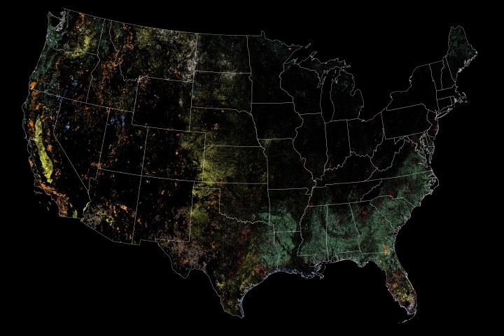
A NASA-funded study published in Nature Geoscience has identified a significant shift in the forces shaping the continental United States. Led by former Landsat science team member Zhe Zhu, the research analysed nearly 35 years of data from NASA and USGS Landsat satellites to determine the primary drivers of landscape change. The findings indicate that while human-directed disturbances are decreasing, wild disturbances are rising, marking a transition in how the American landscape is transformed.
Between 1988 and 2022, land disturbance caused directly by human activity, such as logging, agricultural expansion, and construction, decreased by approximately 600 square kilometres annually. Researchers attribute this decline to a combination of policy changes, technological improvements, and the economic impact of the 2008 financial crisis on construction sectors. In contrast, land affected by wild disturbances, including wildfires, hurricanes, and landslides, increased by more than 200 square kilometres per year.
The study utilised a machine-learning algorithm trained on 40 years of land-change data to differentiate between human and wild disturbances. After a decade of development, the team created a product that achieves over 75 percent accuracy in identifying the causes of land change. This automated approach replaced the historical method of manually inspecting satellite imagery alongside ground observations to determine the source of disturbance.
Cumulatively, 18 percent of the continental U.S. land area was disturbed at least once during the study period. When accounting for repeated disturbances, the total affected area rises to nearly 700,000 square miles, equivalent to almost one-third of the continent. Humans drove more than half of this change, clearing or developing over 446,000 square miles of land. Wild disturbances accounted for the remaining transformation, affecting more than 165,000 square miles.
The rise in wild disturbances is linked to climate warming, drought-related stress, and increased wind disturbances. Ramakrisna Nemani, a retired NASA scientist and co-author on the study, stated that the findings suggest current strategies are ineffective and that new approaches for coexistence are needed. The authors concluded that the United States is entering a new era of disturbance, requiring a shift from controlling the landscape to adapting to natural changes.
Robert Emberson, associate program manager for the NASA Disasters program, highlighted the importance of this data for community resilience planning. He noted that understanding the causal factors of landscape change is critical for future planning, allowing communities to prepare for specific risks such as wildfires through prescribed burns and resilient construction. The study underscores the need for policymakers to develop adaptation strategies that account for the increasing frequency of natural disasters.
The research draws on the deep archive of Landsat data, which has long served as a key resource for detecting changes on Earth’s surface. By providing a detailed history of disturbance causes, the study offers communities a tool to analyse past trends and better plan for the future. The findings suggest that as human influence on land use wanes, the impact of climate-driven natural events will continue to grow, necessitating new frameworks for land management and disaster preparedness.


