Textbook Cloud Formations Mark End of Astronomical Winter Over Gulf of Alaska
The striking atmospheric display, featuring von Kármán vortex streets near Unimak Island, illustrates the transition from a harsh winter season to the instability of early spring.
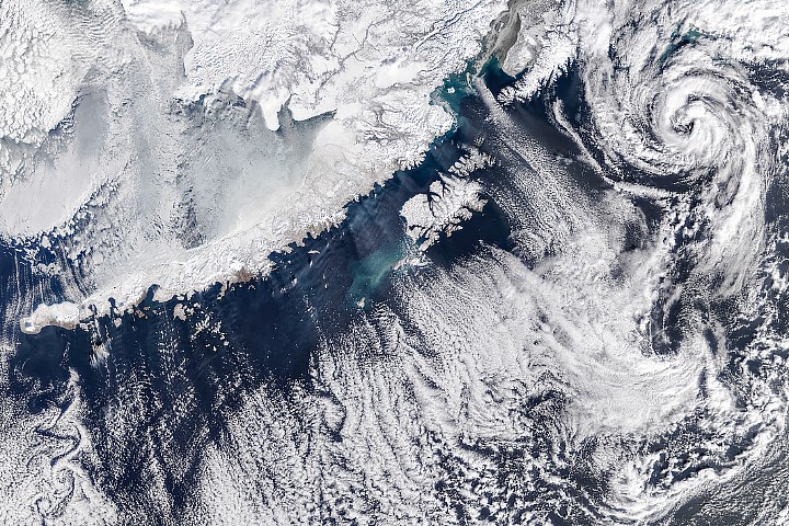
On 19 March 2026, a NASA satellite captured a striking array of cloud formations over the Gulf of Alaska, coinciding with the final day of astronomical winter. The imagery reveals distinct meteorological features, including cloud streets, open-cell clouds, von Kármán vortex streets near Unimak Island, and a polar low approximately 180 miles southwest of Anchorage. These patterns emerged as cold Arctic air moved southeast over the peninsula, interacting with warmer ocean waters to create atmospheric instability.
While the region experienced below-normal temperatures and heavy snow earlier in the season, the specific pressure systems driving this event were low pressure over the Gulf of Alaska combining with high pressure over eastern Russia and northern Alaska. This configuration forced the frigid air mass to pour southeast over the Alaska Peninsula. As the air moved over the comparatively warm ocean surface, it began to gain heat and moisture, a process that initiated the visible cloud structures.
The resulting display includes textbook examples of cloud streets, which appear as parallel bands oriented in line with the direction of the wind. These bands form when frigid, dry air moves over the sea and gains moisture, causing water vapour to condense where the warm air rises. Adjacent to these clouds, where cooled air sinks, the skies remain clear. This transformation requires time over the sea surface, which is why the region close to shore remains mostly cloud-free, though a hazy area of stratus or sea fog may be present.
As the air mass travels farther out into the gulf, the cloud streets mature and evolve into open-cell clouds. These appear as thin wisps surrounding empty pockets, indicating the air mass has progressed further in its development. Another compelling feature is visible toward the bottom-left on the lee side of Unimak Island, the easternmost of the Aleutian Islands. Here, trails of staggered, counterrotating swirls known as von Kármán vortex streets are visible, formed when winds divert around the elevated island.
Perhaps the most striking element in the scene is a larger cloud vortex located approximately 180 miles southwest of Anchorage. Meteorologist Matthew Cappucci identified this feature as a polar low, a small cyclonic formation that develops in cold polar air over relatively warm water. In this specific instance, the polar low carried tropical storm-force winds and produced snow and thunderstorms around its centre.
The image, captured using MODIS data by Michala Garrison for the NASA Earth Observatory, documents the transition from a winter defined by persistent cold and storminess to a complex atmospheric setup. While the month overall brought unsettled weather to the state, this specific snapshot on 19 March 2026 highlights the dynamic nature of the region's weather as winter officially concludes.


