Super Typhoon Sinlaku’s Upper-Atmosphere Gravity Waves Detected by Satellites
Researchers link the phenomenon to storm development, offering potential improvements for weather forecasting and space weather monitoring.
In mid-April 2026, Super Typhoon Sinlaku intensified to Category 5 status in the North Pacific Ocean, bringing heavy rain and flooding to the Mariana Islands. The storm reached “violent typhoon” status, the highest intensity on the Japan Meteorological Agency scale, and was one of only a handful of tropical cyclones of such intensity recorded so early in the year in the region. As the storm rapidly strengthened from Category 2 to Category 5 in the 24 hours prior to April 12, 2026, satellites began detecting its effects extending upward into the upper atmosphere.
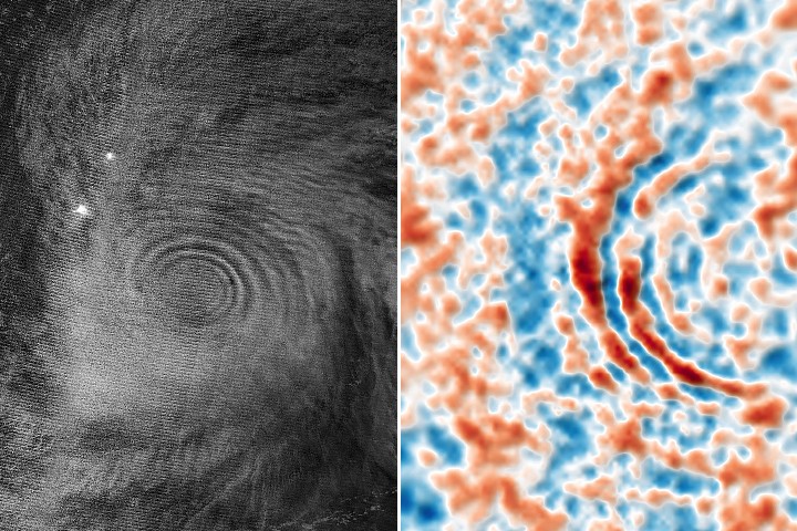
NASA and NOAA satellites observed atmospheric gravity waves radiating from the typhoon. These waves, which resemble ripples on a pond, were generated by “hot towers” of tall cumulonimbus clouds rising from the troposphere. Driven by latent heat release near the cyclone’s eyewall, these clouds push energy upward, creating waves that propagate into the stratosphere and mesosphere. The visibility of these mesospheric airglow patterns was aided by relatively light stratospheric winds and low moonlight, with the Moon approximately 25 per cent illuminated at the time.
Joan Alexander, a senior research scientist at NorthWest Research Associates, noted the distinct cone-like shape of the waves propagating radially and upward. While upper-atmospheric winds often dissipate such waves before they reach high altitudes, the conditions in April 2026 helped preserve the signal. Alexander expressed surprise at the clarity of the waves in the mesospheric airglow, which was captured by the VIIRS instrument on the NOAA-20 satellite.
The phenomenon was also observed lower in the atmosphere by the AIRS instrument on NASA’s Aqua satellite, which detected thermal emissions from the gravity waves in the stratosphere on April 13 and 14. Analysis of past tropical cyclones indicates that gravity waves frequently coincide with periods of storm intensification. This alignment suggests that monitoring these waves could provide valuable data on storm development, particularly over the open ocean where traditional observation methods may be limited.
Laura Holt, also a senior research scientist at NorthWest Research Associates, highlighted the broader implications for weather models and space weather. Stratospheric wind patterns influence long-term forecasts, such as the next Northern Hemisphere winter, and tropical cyclones exert a disproportionate influence on these patterns through sustained convection. Furthermore, gravity waves can cause traveling ionospheric disturbances and plasma bubbles, which have the potential to disrupt satellite signals and radio communications.


