Steam Eruptions and Geothermal Power Define Active Landscape in Western El Salvador
NASA Earth Observatory imagery captures the volcanic terrain of western El Salvador, where persistent geothermal activity and active volcanoes coexist with critical energy infrastructure
Western El Salvador presents a landscape defined by intense geological activity, where the heat beneath the surface has long been harnessed for energy. The region contains the Ahuachapán Geothermal Power Plant, a facility that has supplied 40 per cent of El Salvador's electricity since it began operations in 1975. By the early 1980s, the plant was generating such a significant portion of the nation's power that some scholars noted this high level of production coincided with a period of civil unrest and population growth in the area.
The energy source relies on groundwater naturally heated to approximately 250 degrees Celsius, or 480 degrees Fahrenheit, within local fault systems. This geothermal field is characterised by geysers, mineral pools, and steam vents that feed the power plant. However, the same thermal activity that provides electricity also creates persistent hazards for the surrounding communities. The area is prone to sudden and deadly steam explosions, a risk underscored by a blast in October 1990 near the Laguna Verde volcano within the Apaneca Range.
More recently, these dangers manifested in 2025 when steam eruptions occurred near a popular hot springs facility in the Apaneca Range. The event forced evacuations and caused damage to local infrastructure, serving as a stark reminder of the volatile nature of the terrain. Despite the lack of recorded eruptions for volcanoes in the Apaneca Range during the Holocene, the zone remains active with fumaroles and steam vents that pose ongoing risks to infrastructure in the vicinity.
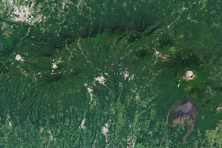
The broader volcanic context of the region is dominated by the Central American Volcanic Arc, which stretches over 1,000 kilometres along the Pacific coast from Guatemala to Panama. On the right side of the landscape, the Santa Ana volcano stands as the country's tallest peak at 2,381 metres. It remains active with small to moderate explosive eruptions recorded since the 16th century, with its most significant recent event occurring in 2005.
To the west lies the dormant Izalco volcano, which historically earned the nickname "Lighthouse of the Pacific" due to the glowing emanations visible from the sea during its frequent eruptions. Although Izalco's last activity was in 1966, it has since powered down, leaving the active Santa Ana and the geothermal fields of the Apaneca Range as the primary sources of thermal activity in the area.
NASA Earth Observatory imagery, utilising Landsat data from the U.S. Geological Survey, highlights this complex interplay between natural hazard and human utility. The image captures the pockmarked craters and recent lava flows near Ahuachapán, alongside the forested peaks of the Apaneca Range, illustrating a region where the earth's heat continues to shape both the environment and the nation's energy security.


