Smoke Shrouds Cascade Volcanoes as Wildfires Spread Across Pacific Northwest
The Grasshopper fire near Mount Hood has burned nearly 84,000 acres, prompting evacuations in Oregon, while smoke from distant blazes degrades air quality at Mount Rainier in Washington.
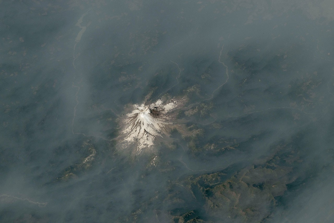
Astronauts aboard the International Space Station have captured striking imagery of wildfire smoke enveloping two of the Pacific Northwest’s most prominent peaks during late July and early August 2026. The photographs, released by NASA, show Mount Hood in Oregon and Mount Rainier in Washington wreathed in haze as wildland fires intensified across the region.
Mount Hood, Oregon’s tallest mountain at 11,249 feet, is pictured above a thick plume of smoke rising from the Grasshopper fire. Ignited by a lightning strike on July 23, the blaze spread rapidly north and east across the Mount Hood National Forest under hot, dry conditions. By August 12, the fire had consumed nearly 84,000 acres and breached national forest boundaries.
The expansion of the Grasshopper fire has triggered severe responses in Wasco County. Authorities issued “go now” evacuation orders for several communities, while residents in the nearby town of Dufur were advised to prepare for immediate evacuation. The fire’s trajectory has been influenced by thunderstorms that passed through the forest in preceding weeks, according to InciWeb.
Approximately 100 miles to the north, Mount Rainier, Washington’s highest peak at 14,411 feet, was also obscured by smoke. While no major fires were burning in the immediate vicinity when an image was taken on August 4, smoke drifted into the area from blazes in central and eastern Washington. Winds associated with a high-pressure system offshore carried the particulate matter eastward, leading the National Park Service to report unhealthy air quality levels due to elevated concentrations of fine particulate matter.
A separate fire, the Grand Park 2, was observed burning within Mount Rainier National Park boundaries as of August 12. Located about three miles north of the Sunrise Visitor Center, the fire had burned 223 acres and remained uncontained. The cause of the Grand Park 2 fire has not yet been determined.
Conditions across the Northwest have been shaped by warm, dry weather and cured fuels, factors influenced by El Niño that have set the stage for large, long-burning fires. The National Interagency Fire Center has indicated that above-normal fire potential is expected to persist through August.
The images were acquired using a Nikon Z9 digital camera with a 400-millimetre focal length by a member of the Expedition 75 crew. They were provided by the ISS Crew Earth Observations Facility and the Earth Science and Remote Sensing Unit at NASA Johnson Space Center. The photographs have been cropped and enhanced to improve contrast, with lens artifacts removed.