Satellite imagery confirms scale of EF-3 tornado path in southern Mississippi
The strongest of seven tornadoes that struck the state on 6 May 2026 left a 132-kilometre track of damaged vegetation, with over 400 homes reported damaged in Lincoln County.
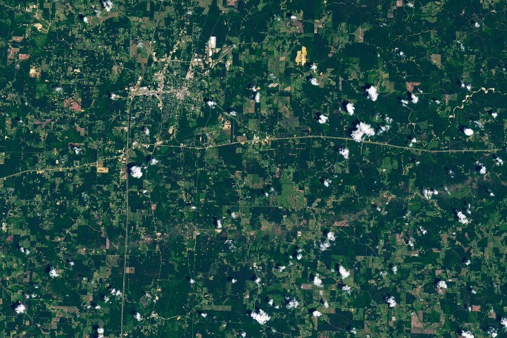
A powerful supercell storm produced multiple tornadoes across southern Mississippi on 6 May 2026, with the most significant event leaving a distinct mark on the landscape. According to NASA, the strongest tornado reached EF-3 intensity, delivering wind speeds of up to 137 miles (220 kilometers) per hour. The event spanned five counties, with the most severe damage concentrated in Lincoln County, where the Mississippi Emergency Management Agency reported damage to more than 400 homes, alongside numerous businesses and farm buildings.
NASA’s Earth Observatory captured the aftermath using data from the Landsat 8 satellite on 12 May 2026. The imagery reveals a brownish track across the terrain where winds snapped, uprooted, and tore bark and branches from trees. This visible path of damaged vegetation extends south of Brookhaven in Lincoln County, an area that sustained EF-3 damage. The satellite view provides a clear visual record of the storm’s impact on the region’s vegetation and infrastructure.
National Weather Service (NWS) post-event assessments corroborated the satellite findings, noting extensive tree damage, a home with collapsed exterior walls, and a mobile home park described as devastated with debris. The tornado began at the St. Catherine Creek National Wildlife Refuge near the Mississippi River, approximately 60 miles west-southwest of Brookhaven. In just over two hours, it travelled nearly 82 miles (132 kilometers), placing it among the longest tornadoes recorded in the state.
Beyond the primary EF-3 track, NWS surveys identified several instances of EF-2 structural damage along the path, including bent or collapsed transmission towers. Preliminary NWS data as of 20 May 2026 confirmed that seven tornadoes occurred in Mississippi on the evening of 6 May. The majority of the reported damage to homes and businesses was located in Lincoln County, highlighting the concentrated impact of the supercell system.
While the Gulf Coast and southeastern states are not part of the traditional Tornado Alley, they remain tornado-prone, particularly in spring and late autumn. Historically, April is the peak month for tornadoes in Mississippi, averaging more than seven, while May averages just over three. Recent analyses indicate a shift in patterns, with decreases in tornado frequency in the Great Plains and increases in the Southeast over several decades.


