Satellite imagery captures dynamic ice breakup and flooding along Alaska’s Kuskokwim River
Landsat 9 observations detail the progression of a dynamic breakup event that triggered a flood watch and inundated low-lying areas in May 2026.
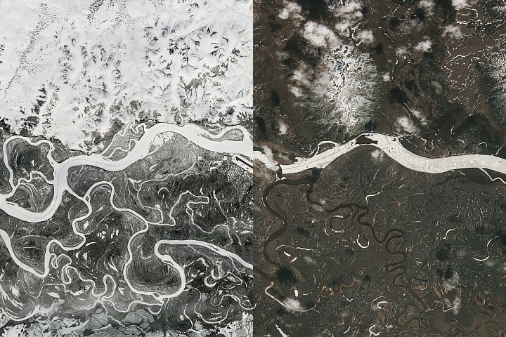
Spring thaw along Alaska’s Kuskokwim River triggered significant ice jams and flooding near the town of Aniak in May 2026. NASA Earth Observatory imagery from Landsat 9 captured the sequence of events, documenting the ice breakup and subsequent jamming that led to a flood watch issued on May 8. The resulting waters inundated low-lying areas and encroached on properties near the east side of the town’s runway before receding two days later.
The landscape along the river appeared frozen in a Landsat 9 image acquired on April 21, 2026. According to observations published by the Alaska-Pacific River Forecast Center, river ice near Aniak remained thick and covered in deep snow as of April 16. The thick ice had previously supported the Kuskokwim ice road, a route extending approximately 350 kilometres that connected numerous villages and shut down for the season on April 10.
Conditions changed rapidly around May 7, when the front of the ice breakup had nearly reached Aniak. A sheet of grounded ice caused a jam stretching 21 kilometres upstream, with news reports indicating ice chunks several feet thick piled up on riverbanks around the town. Although the ice backup began to flow downstream by May 7, ice clogged the river again later that night several miles downstream from the community.
Forecasters attributed the hazard to a dynamic breakup, a scenario where above-average snowpack and thick winter ice encounter sudden warmer temperatures, causing rapid water backup. Snowpack was above average in some major river drainages, and historically low temperatures marked the winter and spring months. For instance, the March average temperature in Bethel, located downstream of Aniak, was 14 degrees Fahrenheit below normal.
Experts noted that while floods had been relatively minor along large rivers through early May 2026, more severe flooding still had the potential to develop quickly. The event highlights the risks associated with spring melt, where thawing brings the threat of rapid flooding as river ice breaks up and periodically jams, particularly when snowmelt encounters intact ice.


