Satellite data reveals Lake Naivasha’s dramatic expansion amid Kenya flooding
Relentless rainfall and a closed basin system have swollen the Kenyan lake, displacing residents and threatening the vital flower industry.
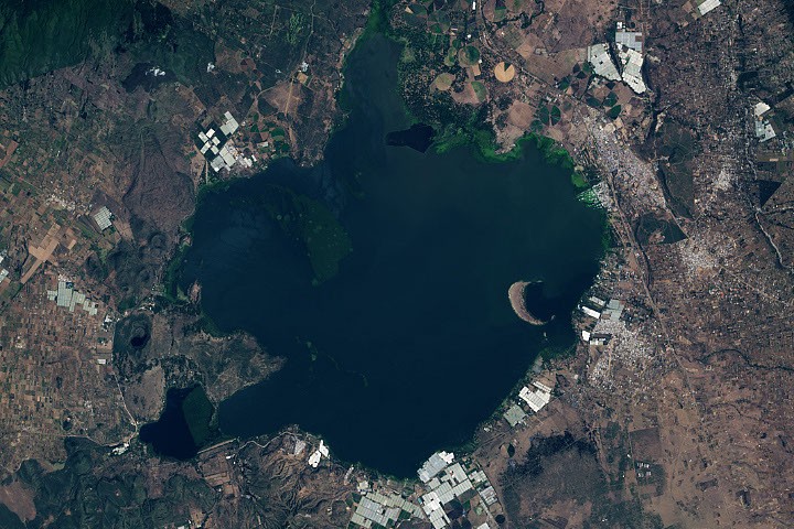
Relentless rainfall has caused Lake Naivasha in Kenya’s Great Rift Valley to rise significantly, threatening homes, infrastructure, and the local flower industry. Satellite data indicates the lake's depth has increased by approximately 7 metres since 2010, with its area expanding by 40 percent. The flooding has displaced residents, inundated town blocks in Kihoto, and submerged flower farms, while also merging Lake Naivasha with the saline Lake Oloidien.
The name Naivasha derives from a Maasai word meaning "that which heaves," a description that has become increasingly apt over the past 25 years. According to satellite altimetry measurements, the lake’s depth has risen by about 7 metres, equivalent to the height of a two-story building. Over the same period, Landsat imagery recorded a roughly 40 percent increase in the lake's surface area, adding 50 square kilometres of water.
Mathew Herrnegger, a hydrologist at BOKU University in Vienna, identified increased rainfall as the primary driver of this expansion. Mean annual rainfall rose by about 30 percent between 2010 and 2020 compared to the preceding decade, accompanied by a 318 percent increase in high-intensity rainfall events. Herrnegger and his colleagues estimate that a modest 0.4 to 2.0 percent increase in annual rainfall is sufficient to explain the dramatic rises in water levels.
Because the lake lies in a closed basin with no surface outflow, it is highly sensitive to changes in the water balance. The rising waters have caused Lake Naivasha to merge with the adjacent saline Lake Oloidien, introducing alkaline water into the freshwater ecosystem. This shift, combined with the proliferation of aquatic vegetation such as water hyacinth, is interfering with fishing and tourism while potentially slowing evaporation rates.
The human and economic toll is considerable. Flooding has inundated entire town blocks in the Kihoto neighbourhood, including police stations, churches, and electrical power substations. The flower industry, which generates hundreds of millions of dollars in exports annually, is losing greenhouses, farmland, and worker housing. In communities such as Sulmac Village and Karagita, properties that were once set back from the water now face direct lakeshore exposure.
Jamie Shutler, a professor of earth and environmental science at the University of Exeter, noted that other factors may be contributing to the changes. These include tectonic influences altering groundwater recharge rates and sediment accumulation reshaping the lake floor. Shutler emphasised the need for further research to assess exactly how much the volume of water is changing each year and why, given the large number of people who rely on the lake for their livelihoods.