Satellite data confirms new submarine volcanic eruption in the Bismarck Sea
Seismic swarms and thermal anomalies detected since 8 May 2026 suggest a shallow vent, with scientists monitoring for potential new land formation.
A new submarine volcanic eruption has been confirmed in the Central Bismarck Sea, north of Papua New Guinea, following seismic and satellite observations that began on 8 May 2026. The activity is located along the Titan Ridge, approximately 16 kilometres southeast of a previous submarine eruption recorded in 1972. While the precise volcanic feature remains unidentified due to limited high-resolution bathymetric mapping in the region, data from multiple space agencies indicates active magma movement near the surface.
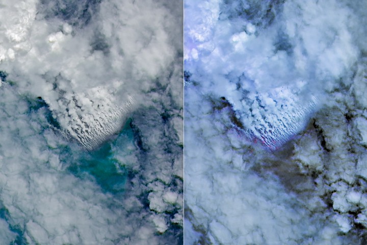
Seismometers detected a small swarm of earthquakes on 8 May, marking the onset of the event. This was followed by optical and thermal imagery from NASA’s Aqua and Terra satellites, which captured white, steam-rich plumes rising into the atmosphere. NASA’s PACE satellite further revealed discoloured and disturbed water surrounding the site, while European Space Agency’s Sentinel-2 and NASA/USGS Landsat 9 provided higher-resolution views of the surface activity.
On 12 May, the VIIRS sensor on the Suomi NPP satellite detected thermal anomalies spanning roughly seven square kilometres. Simon Carn, a volcanologist at Michigan Tech, noted that the intensity of these thermal signatures suggests a shallow eruption vent, significantly closer to the surface than the existing bathymetry, which indicates water depths of several hundred metres or more.
The eruption has produced ash plumes, discoloured water, and extensive pumice rafts forming long bands in surface currents. Scientists suggest the event is likely less explosive than recent major submarine eruptions at Hunga Tonga-Hunga Ha'apai in 2022 and Fukutoku-Okanobain in 2021. This reduced explosivity is attributed to the volcano’s location on a spreading centre near a transform fault, rather than a subduction zone typically associated with highly explosive stratovolcanoes.
Jim Garvin, chief scientist at NASA’s Goddard Space Flight Center, highlighted the opportunity to study the event using government and commercial satellite platforms. Researchers plan to utilise radar data from the NASA-ISRO NISAR satellite and the Canadian Space Agency’s RADARSAT Constellation Mission to map any emerging land. If a new island forms, it could provide a unique opportunity for scientists to observe island formation and subsequent ecological colonisation.


