Radiation fog blankets Victorian Alps as arch-shaped cloud forms over Port Phillip Bay
Morning mist fills shaded valleys in eastern Victoria while a unique cloud formation drifts across the bay, illustrating the region's dynamic weather patterns.
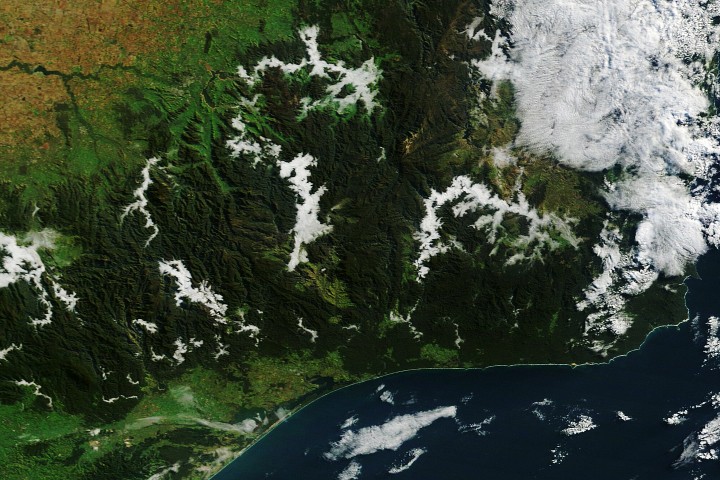
NASA's Terra satellite has captured striking imagery of atmospheric conditions across eastern Victoria, revealing a landscape divided by two distinct weather features. In the Victorian Alps, thick valley fog has blanketed several national parks, while simultaneously, an arch-shaped cloud has drifted across Port Phillip Bay. This event occurred during May, a period marking autumn in the Southern Hemisphere and traditionally known as fog season in the alpine regions.
The formation of the radiation fog in the mountains is a result of specific atmospheric conditions that allow cold air to sink and accumulate in shaded valleys. As nights lengthen during the autumn season, the atmosphere has sufficient time to cool and approach the dew point, causing water vapour to condense. Because cold air is denser than warm air, it drains into these low-lying areas where it remains trapped longer than in open terrain. This tendency for the fog to linger is amplified by the presence of local rivers, streams, and lakes, which provide a steady supply of water vapour to sustain the low-lying cloud.
Geostationary satellite imagery indicates that the fog persisted for approximately two hours before dissipating. The phenomenon was particularly evident along several major water bodies, including the Mitta Mitta River, Buffalo River, Livingston Creek, Lake Dartmouth, and the Snowy River. These zones of fog formed where the cold, dense air settled over the water surfaces, creating a dense layer that obscured the valleys beneath.
While the alpine regions experienced mist, a different meteorological process was occurring a few hundred kilometres to the southwest over Port Phillip Bay. At approximately 8:19 a.m. local time, the Terra satellite recorded an arch-shaped cloud stretching from St Leonards on the western shore to Mount Eliza on the eastern side. This feature likely developed from the interaction of converging land and sea breezes with the unique horseshoe-shaped terrain that defines the bay.
The weather patterns leading to these formations were driven by a sequence of recent atmospheric shifts. A blast of cold, moist air initially primed the region by moistening the land surfaces. This was followed by the arrival of a slow-moving high-pressure system that brought calmer and warmer conditions, creating an environment conducive to both the formation of radiation fog in the valleys and the development of the arch-shaped cloud over the bay.
The imagery, captured by the Terra satellite using MODIS data, highlights the diverse cloud formations that can occur within a single day across Australia. The story, produced by the NASA Earth Observatory, underscores the importance of satellite observation in monitoring and understanding the complex interactions between terrain, temperature, and moisture that shape the Australian landscape.


