NISAR Satellite Radar Reveals ‘Hummingbird’ Feature in Antarctica
New imagery from the NISAR satellite highlights Nunatak Zaterjavshijsja in East Antarctica, where ice fractures appear as sharp green lines due to volume scattering of microwave signals.
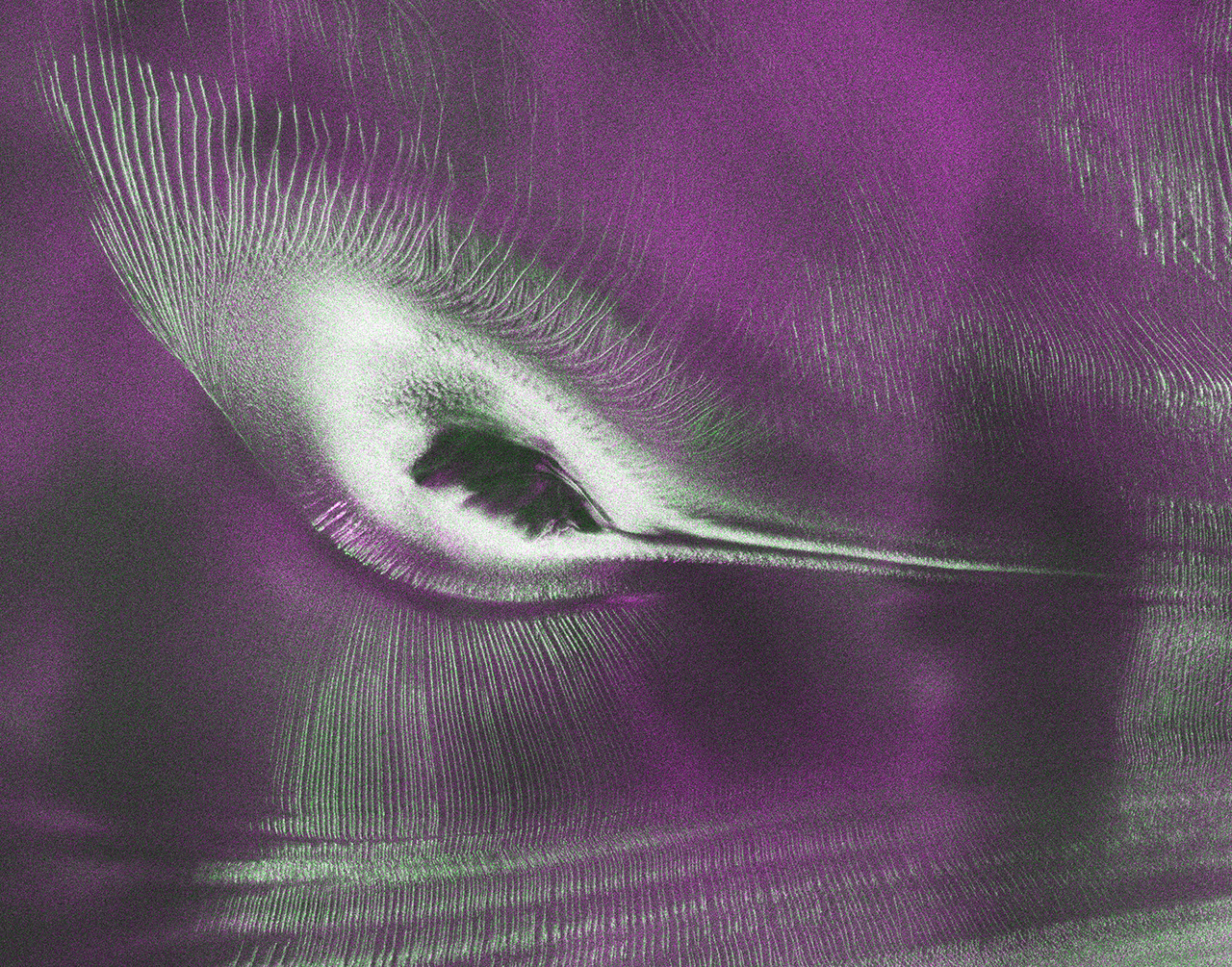
Data from the Earth-orbiting NISAR (NASA-ISRO Synthetic Aperture Radar) satellite has produced a detailed image of Nunatak Zaterjavshijsja, a mountaintop in East Antarctica protruding from a stream of ice flowing northeast towards the ocean. The resulting visualisation, nicknamed “the hummingbird” by NISAR scientists, was produced in August 2025 and captures the stresses caused by the obstruction, which heavily fractures the surrounding ice surface with deep crevasses.
The image utilises L-band radar data to visualise these features through colour coding that represents the polarisation of returned microwave signals. Signals returning with horizontal polarisation, which likely bounced off regular surfaces such as smooth ice, are depicted in magenta. In contrast, sharp green lines indicate vertical polarisation resulting from volume scattering, where radar signals partially penetrate the ice or scatter at different angles off irregular surfaces like the faces of crevasses.
White areas in the image represent regions where both horizontal and vertical signals scatter back strongly, suggesting an equal blend of surface and volume scattering. This technique allows scientists to distinguish between smooth ice sheets and fractured zones, providing clear visual evidence of the structural stress exerted on the ice flow by the nunatak.
The NISAR satellite is the first mission to carry two synthetic aperture radar instruments at different wavelengths. It collects data using a giant drum-shaped reflector that measures 39 feet (12 meters) wide, making it the largest radar antenna reflector NASA has ever sent into space. This hardware capability enables the high-resolution imaging required to identify such specific geological and glaciological features from orbit.
NASA’s Jet Propulsion Laboratory, managed by Caltech, leads the United States component of the project and provided the satellite’s L-band SAR and antenna reflector. The Indian Space Research Organisation contributed the spacecraft bus and the S-band SAR instrument. Together, these components allow the mission to monitor Earth’s changing ecosystems, natural hazards, and ice mass dynamics with unprecedented precision.