New NISAR Satellite Mapping Reveals Accelerated Sinking in Mexico City
A new visualisation highlights the impact of groundwater extraction on the ancient lakebed foundation, pinpointing the Angel of Independence and local wetlands among the affected zones.
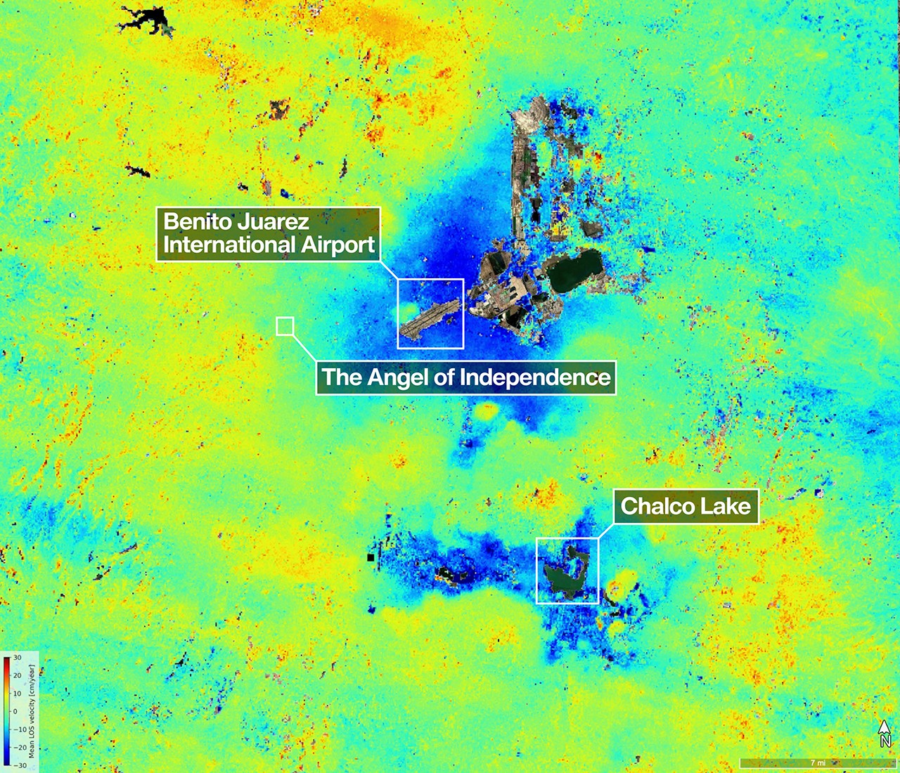
A scientist has produced a detailed map of land subsidence in Mexico City using data from the NISAR mission, a joint project between NASA and the Indian Space Research Organisation. The imagery, derived from radar signals captured between 25 October 2025 and 17 January 2026, highlights areas where the ground is sinking by more than half an inch per month. This visualisation serves as confirmation that the satellite is performing as expected during its first year of operation.
The map indicates that the rapid sinking is occurring primarily due to groundwater pumping, which causes the compaction of the dry, ancient lakebed on which the city was built. Mexico City sits atop the drained bed of Lake Texcoco, a geological reality that has complicated infrastructure development for over a century. While an engineer first documented the issue in 1925, the rate of compaction has historically reached approximately 14 inches per year in parts of the metropolitan area during the 1990s and 2000s.
Specific landmarks and ecosystems identified in the new imagery include the Angel of Independence monument along the Paseo de la Reforma. Built in 1910 to commemorate 100 years of Mexico's independence, the structure stands over 100 feet tall and has required 14 additional steps to its base over the years as the land beneath it has gradually sunk. The map also distinguishes two marshy ecosystems: Nabor Carrillo, an artificial lake constructed over the extinct Lake Texcoco, and Chalco Lake, a wetland located in a historically fertile region to the south.
Yellow and red areas visible on the map are currently identified as likely residual noise signals. These anomalies are expected to decrease as the NISAR mission continues to collect more data and refine its measurements. The satellite's unique capability to carry two Synthetic Aperture Radar instruments at different wavelengths allows it to penetrate dense vegetation and monitor agriculture, providing a level of detail that supports global disaster response and environmental research.
The ancient lakebed was also a primary natural habitat for the Mexican Axolotl, an endangered species of salamander. The ongoing compaction of the sediment poses risks to critical infrastructure, including the Metro rapid transit system. By mapping these changes, researchers aim to better understand the surface dynamics of the region and assist in mitigating damage from geological shifts.


