NASA’s Psyche Spacecraft Captures High-Resolution Martian Terrain During Flyby
Enhanced-colour images from the Psyche mission reveal geological features including the Fournier crater and Oenotria Scopuli scarp system during a May 2026 flyby.
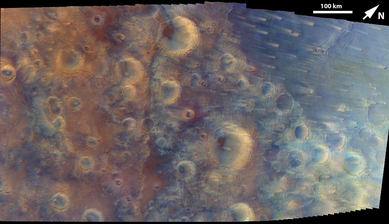
NASA’s Psyche spacecraft has returned a high-resolution mosaic of the Martian surface, captured during a flyby on 15 May 2026. The images were acquired by the mission’s multispectral imager over a six-minute period as the spacecraft travelled from northeast to southwest across the planet. While the primary objective of the Psyche mission is to study a metal-rich asteroid, this flyby served as a critical opportunity for navigation verification and instrument calibration.
The resulting mosaic covers a section of the Iapygia region within Mars’ rugged southern highlands. The area spans from approximately 62 to 78 degrees east longitude and 4 degrees north to 14 degrees south latitude. The image resolution varies across the frame, ranging from 381 metres per pixel on the right side to 440 metres per pixel on the left, reflecting the spacecraft’s motion and changing distance from the surface during the acquisition window.
To highlight specific geological contrasts, the imager utilised near-infrared, green, and blue filters. This technique produced an enhanced-colour representation of the terrain, distinguishing between highly contrasting features such as craters, ridges, wind streaks, and volcanic plains materials. It is important to note that these colours are processed to emphasise surface characteristics and do not represent true-colour human vision.
The most prominent feature visible in the mosaic is the Fournier crater, located just below the centre of the frame. This impact structure measures approximately 114 kilometres in diameter. The clarity of the imagery allows for detailed observation of the crater’s morphology and its relationship to the surrounding volcanic plains.
Running vertically just to the left of the centre is a linear feature identified as part of the Oenotria Scopuli. This is a long, irregular cliff or scarp system that forms part of the circular structure of the large Isidis impact basin, which lies to the northeast of the captured area. The data provides further context for the complex geological history of the Iapygia region and its proximity to major ancient impact structures.
The images were released by NASA as part of its ongoing documentation of the Psyche mission’s journey. The successful capture of these details confirms the operational status of the multispectral imager and demonstrates the spacecraft’s capability to conduct high-precision remote sensing while in transit to its primary target.