NASA Satellites Detect Prescribed Burns Across Australia’s Northern Territory
Satellite imagery from May and June 2026 reveals extensive fire activity that land managers attribute to intentional prescribed burns, aiming to mitigate the severity of later wildfires.
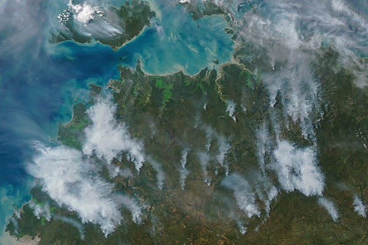
NASA satellites have detected extensive fire activity across Australia’s Northern Territory during May and June 2026, with significant concentrations in the Top End and Arnhem Land regions. Analysis of the thermal anomalies and smoke plumes captured by orbital instruments indicates that a substantial portion of these blazes are prescribed burns intentionally lit by land managers. The objective of these operations is to reduce fuel loads early in the dry season, thereby minimising the severity and emissions of subsequent high-intensity wildfires.
The dry season in the Northern Territory generally commences in May and extends through September, according to the Bureau of Meteorology. During this period, land managers utilise programs such as the West Arnhem Land Fire Abatement project and the Arnhem Land Fire Abatement project. These initiatives integrate deep-rooted Indigenous land management practices with modern technology to establish large-scale landscape management strategies. The fires typically burn through the fire-adapted grasses, underbrush, and scattered trees characteristic of the region’s tropical savanna ecosystems.
Satellite observations highlight distinct patterns in the timing and appearance of these fires. On the afternoon of May 28, 2026, NASA’s Aqua satellite captured imagery showing expansive smoke plumes from the blazes. In contrast, thermal anomalies detected by NASA satellites in the mornings surrounding that date indicated fire activity with little visible smoke. This pattern is consistent with morning prescribed burns, where smoke builds over the course of the day and is carried away by updrafts and moderate winds, as observed again on June 2.
The practice of prescribed burning is designed to create firebreaks and reduce combustible material before conditions become critical. By shifting fire activity to the early dry season, land managers aim to prevent the occurrence of destructive, emissions-intensive fires later in the year. While research is ongoing, current satellite analysis suggests that these efforts are having the intended effect, with signs indicating a shift in fire activity from late to early in the dry season.
Despite the clear visual evidence of these management operations, definitive quantitative proof regarding the reduction in emissions or fire intensity remains under study. The data, derived from MODIS instruments via NASA EOSDIS LANCE and GIBS/Worldview, provides a detailed view of the landscape changes but underscores the need for continued monitoring to fully assess the long-term impact of these prescribed burning programs on regional fire dynamics.


