NASA report details geological forces shaping Maine’s dual coastlines
A new analysis from the NASA Earth Observatory explains how bedrock variations and glacial history created the state’s distinct sandy and rocky shores, with direct implications for local economies.
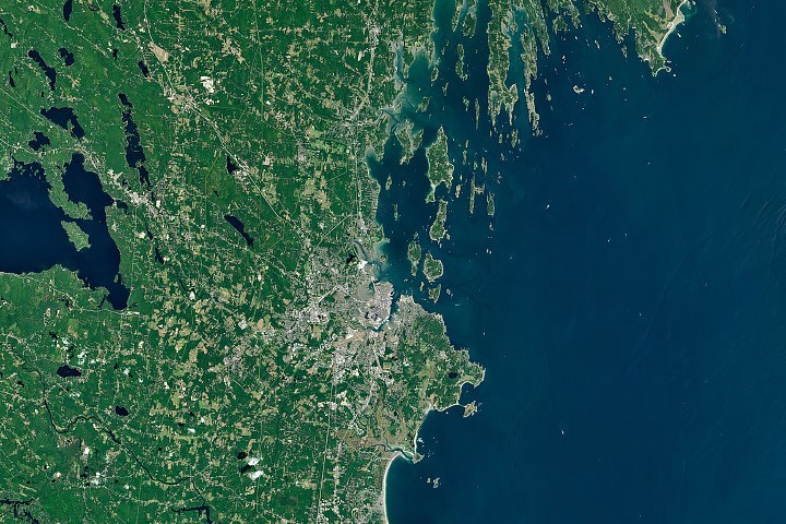
A recent report from the NASA Earth Observatory attributes the sharp contrast between Maine’s sandy beaches south of Portland and its rocky, indented coastlines to the northeast to differences in underlying bedrock and sediment distribution. The study highlights how geological history has shaped not only the physical landscape but also the economic activities of coastal communities, from tourism to fisheries.
Southern Maine features broad deposits of sand, much of it sourced from rivers. The sandy beaches of Saco Bay, for instance, received sediment from the weathering and breakdown of the White Mountains, with material transported to the coast largely by the Saco River. Waves and tides reworked these soft sediments over time, sculpting them into the arch-shaped embayed beaches and sprawling salt marshes found around Saco Bay and the broader region.
While erosion-resistant granite juts from the sandy shorelines in southern Maine to form rocky headlands, metamorphic bedrock becomes the dominant surface feature east of Portland. There, whole ridges and valleys made of rock layers transformed by exposure to high pressures and temperatures define the landscape. During the last ice age, glaciers scoured and widened many of these coastal valleys, which later flooded as the Laurentide Ice Sheet melted and sea levels rose.
Around Casco Bay, these ridge-and-valley systems, combined with the drowning of the shoreline, produce the jagged, highly indented shoreline and many long, narrow islands seen today. Nicholas Whiteman of the Maine Geological Survey noted that the tortured folds of these old landscapes set up a sharp directional preference for erosion, leading to the distinct orientation of islands and necks in Casco Bay compared with those to the northeast.
The various forms that coastlines take fascinate geologists, but they also carry everyday implications for the economies of Maine's coastal communities. While tourists flock to the sandy beaches of communities like Saco and Kennebunkport, the state's iconic lobster fisheries are concentrated in Midcoast Maine. The crustaceans thrive in the cold waters of the region's many rocky, protected inlets, turning communities such as Harpswell into leaders in lobster landings.
The state's oyster farms are also concentrated in this region. Casco Bay and the Damariscotta Estuary, sheltered from winds and waves, offer waters that farmers can easily access without large boats. These waters provide a range of temperatures, salinities, and other characteristics that create numerous microclimates where oysters can grow quickly and take on a variety of tastes, known as merroir, explained Tom Kiffney, a researcher at the University of Maine.
NASA Earth Observatory image by Michala Garrison, using Landsat data from the U.S. Geological Survey.