NASA releases orbital imagery of Olympic Mountains’ geological and ecological shifts
Newly released photographs from the International Space Station reveal the complex interplay of erosion and uplift in the Olympic Peninsula, alongside the historic removal of dams on the Elwha River.
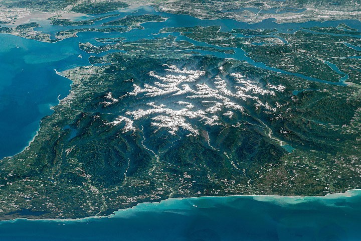
NASA has released a composite image of the Olympic Mountains in northwestern Washington state, captured by an astronaut aboard the International Space Station. The view highlights snow-capped peaks, alpine glaciers, and deep river valleys, including the Hoh, Queets, Quinault, and Elwha rivers. The text notes that tectonic uplift is currently balanced by erosion, and that glaciers in the region are retreating. It also details the history of the Elwha River, including the removal of two dams in 2011 and 2014 to restore fish populations.
The image is a composite of several sequential, overlapping photos (ISS047-E-104138 through ISS047-E-104144) fused into a panorama, which have been cropped, enhanced for contrast, and had lens artifacts removed. A 2015 study cited in the source tallied 255 glaciers and perennial snowfields in the range, finding that 35 glaciers and 16 perennial snowfields had disappeared in the preceding 35 years.
The Elwha dam removal project is described as the largest such project in the U.S. at the time, aimed at restoring fish populations, seeding native plant communities, and replenishing sediment along riverbanks. The Strait of Juan de Fuca is described as 11 to 17 miles (18 to 27 kilometres) wide, with the U.S.-Canada border running through its middle.
The specific date of the ISS photograph acquisition is May 6, 2016, taken by a member of the Expedition 47 crew using a Nikon D4 digital camera with a 400-millimetre focal length. The rock making up the mountains mostly originated beneath the surface of the ocean, with layers of basalt from undersea eruptions and sand and mud transported seaward by rivers accumulating on the ocean bottom.
This material was scraped off the Juan de Fuca plate as it subducted beneath the North American plate, with rock layers crumpling and rising up to 8,000 feet (2,440 meters) above sea level. Tectonic forces continue to push the mountains skyward, but the countervailing force of erosion in this rainy, snowy corner of the country effectively cancels out the uplift.
Snow at higher elevations feeds glaciers that carve out underlying rock. Glaciers in the Olympics are retreating and thinning, however, and their numbers are declining. Other erosion is evidenced by the deep valleys radiating out from the snowy peaks.
The Hoh, Queets, and Quinault rivers, draining west into the Pacific Ocean, are prominent in this view. These verdant valleys are known for their temperate rainforests, and the ancient forest in the Hoh River valley was once considered among the most naturally quiet places in the U.S., uninterrupted by human-caused noise.