NASA releases ISS image revealing Seattle’s glacial and human-modified landscape
The image, designated ISS074-E-723719, documents how the Puget lobe of the Cordilleran ice sheet sculpted Seattle’s topography and how subsequent human activity reshaped its waterways and hills.
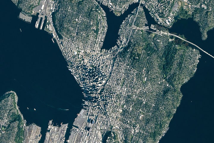
NASA has released an astronaut photograph of Seattle, Washington, taken on June 16, 2026, by a crew member of Expedition 74 aboard the International Space Station. The image, designated ISS074-E-723719, illustrates the city’s topography, which was originally shaped by glacial activity during the last ice age and subsequently modified by significant human engineering projects.
The broad contours of the landscape owe their shape to the advance and retreat of the Puget lobe of the Cordilleran ice sheet. Between roughly 18,000 and 16,000 years ago, a mass of ice up to 1,000 metres thick covered the area, scouring the basins now occupied by Puget Sound and the region’s lakes. Above ground, the glacier left behind elongated mounds of debris known as drumlins, which form several of Seattle’s hills and run north-south, parallel to the direction of the ice’s movement.
The ice also transported large boulders from more northerly locations, depositing them as glacial erratics. One such feature, the Wedgwood Rock, stands approximately six metres tall in a North Seattle neighbourhood. The photograph highlights these geological remnants alongside the city’s modern infrastructure, including tall buildings downtown and ships navigating the surrounding waterways.
In more recent history, human activity has further altered the terrain. Notable alterations include the leveling of Denny Hill north of downtown and the filling of tideflats at the mouth of the Duwamish River south of downtown. This reclamation created approximately 1,300 acres of new land, upon which Seattle’s professional sports stadiums are situated.
The image also captures waterfront infrastructure developments completed after 2010, including a new ferry terminal and a rebuilt seawall. These updates follow earlier engineering efforts, such as the construction of canals in the 1910s to connect Lake Washington to Puget Sound, which lowered the lake’s water level by about three metres. The photograph was acquired using a Nikon Z9 digital camera with a 560-millimetre focal length and is provided by the ISS Crew Earth Observations Facility.