NASA mission samples smoke from Utah wildfire pyrocumulonimbus clouds
Atmospheric sampling reveals how pyrocumulonimbus clouds inject particles into the stratosphere, aiding efforts to forecast dangerous fire weather phenomena.
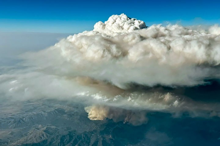
NASA scientists have conducted atmospheric sampling of smoke from the Widemouth 2 wildfire in Utah using the ER-2 and GV aircraft as part of the INSPYRE mission. The team analysed towering pyrocumulonimbus clouds generated by the blaze, which injected particles into the stratosphere. The mission aims to improve forecasting for these dangerous weather phenomena and understand their impact on the upper atmosphere.
The INSPYRE team completed a sampling run on August 3, 2026, flying through a high-altitude smoke pulse from the Widemouth 2 fire. The Widemouth 2 fire was ignited by lightning on July 27, 2026, and more than doubled in size on August 2 amid intense winds and hot, dry conditions. The fire burned more than 150 square miles and swept through parts of a ski resort.
NASA’s Aqua satellite captured images showing a chimney of high-altitude cloud and smoke casting a shadow on low-altitude smoke below. Cloud-top brightness temperatures were measured well below −40°C, indicating the clouds reached the top of the troposphere and sometimes the stratosphere. A pre-dawn pyroCb event was also observed from the same fire, which is considered unusual as morning pyroCbs do not benefit from daytime heating.
The GV aircraft sampled smoke at roughly 12 kilometers (8 miles) above the surface, a height not typically incorporated into forecast models. Since the beginning of 2026, at least 13 pyroCb events have been identified in the continental United States. Scientists estimate that wildfires may contribute up to 25 percent of the black carbon and organic aerosols in the lower stratosphere.
Understanding these enigmatic clouds is critical for fire forecasters and officials. Multiple pyroCbs in a single day can add complexity to evacuation orders and fire management. The INSPYRE mission seeks to minimise uncertainty by collecting data at altitudes that are rarely sampled, providing insights into how these clouds influence the ozone layer and Earth's energy budget.