NASA imagery tracks Canadian wildfire smoke drifting across Ontario and the U.S.
Satellite data from mid-July 2026 shows smoke moving southeast over Quebec and the American Midwest as fire activity returns to near 25-year averages.
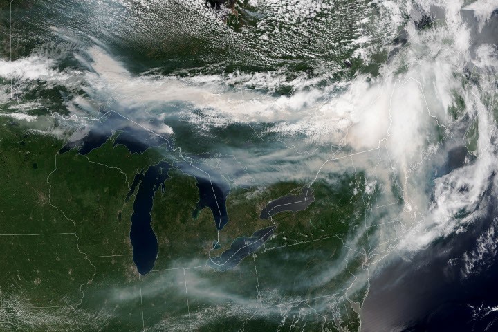
Canadian wildfires have sent extensive plumes of smoke streaming over Ontario, Quebec, and parts of the U.S. Midwest and Northeast, according to data from NASA. By mid-July 2026, nearly 850 fires were actively burning across the country, a significant increase from a slow start to the season. The Canadian Interagency Forest Fire Centre reported that activity picked up by the end of June amid dry and warm conditions, returning closer to the 25-year average for this time of year.
More than 180 of these fires were burning in Ontario at that time. A NOAA-21 image acquired on the afternoon of July 14, 2026, captured smoke billowing from these fires. Winds carried the plumes primarily southeast over much of southern Ontario, as well as parts of Quebec and the U.S. Midwest and Northeast. The smoke tinted the sky in shades of gray and yellow and turned the sun orange in many affected areas.
The impact on air quality varied significantly depending on altitude. In areas where the smoke remained high in the atmosphere, impacts were negligible. However, where the smoke drifted closer to the ground, conditions worsened. Air quality in Toronto reached unhealthy levels, according to AirNow. Residents in the southern parts of the province were also grappling with a regional heatwave, compounding the health risks associated with poor air quality.
Much of the smoke originated from fires in Northwestern Ontario, where eight blazes experienced significant growth on July 13 and 14. These fires prompted officials to issue evacuation orders for several communities in that part of the province, according to news reports. The dense smoke and orange skies were confirmed in reports from Al Jazeera Global News around July 16, 2026.
As of July 14, fires across Canada had burned 1.9 million hectares since the start of the year. While substantial, this total remains well below the season totals recorded during the extreme fire years of 2023 and 2025. A seasonal fire outlook, compiled by wildland fire experts from the U.S., Canada, and Mexico, indicates fire likelihood through July, August, and September, though how the rest of the season plays out remains to be seen. The NASA Earth Observatory image was created by Lauren Dauphin using VIIRS data from NASA EOSDIS LANCE, GIBS/Worldview, and the Joint Polar Satellite System.