NASA imagery captures Typhoon Jangmi’s intensification over the Philippine Sea
Typhoon Jangmi brought torrential rain and flooding risks to Okinawa and the Amami region in late May and early June 2026, with sustained winds reaching 130 kilometres per hour.
Typhoon Jangmi, a broad and slow-spinning system moving north-northwest over the Philippine Sea, delivered torrential rainfall across southern Japan from late May into early June 2026. The storm triggered flooding concerns in several areas as its rainbands unleashed heavy precipitation across a vast swath of the region.
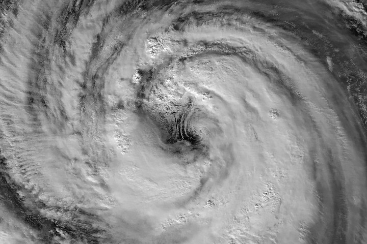
NASA satellite imagery documented the storm’s evolution, capturing its large eye and mesocyclones as it intensified. The Visible Infrared Imaging Radiometer Suite (VIIRS) on the Suomi NPP satellite recorded a nighttime image of the system at approximately 16:40 Universal Time on May 30. At that time, the Joint Typhoon Warning Center reported sustained winds of 120 kilometres per hour, equivalent to a Category 1 storm on the Saffir-Simpson hurricane wind scale.
Scott Braun, a research meteorologist at NASA’s Goddard Space Flight Center, noted that the storm’s eye diameter was on the larger end of the spectrum. The imagery also revealed low-level rotation on the eastern side of the eye, producing features known as mesocyclones. Although partially obscured by high-level clouds, Braun observed that these features are fairly typical for such systems.
One day later, the VIIRS instrument on the NOAA-20 satellite captured a wider view of the storm at approximately 16:40 Universal Time on May 31. By this time, Jangmi had intensified to sustained winds of 130 kilometres per hour. In both images, the typhoon’s eye remained south of Okinawa, although its outer cloud bands had already reached over land as the system moved north.
Forecasts indicated that the storm would make a close approach to Okinawa before turning northeast toward the Amami region around June 1 to 2. News reports suggested that Jangmi was expected to continue delivering large amounts of rain, particularly along Japan’s Pacific coast. The images were produced by Michala Garrison using data from NASA EOSDIS LANCE, GIBS/Worldview, and the Joint Polar Satellite System.


