NASA Earth Observatory captures Ireland’s legacy on Lake Michigan’s largest island
The feature highlights the island’s formation by retreating ice sheets, its historic role as a major fish supplier, and its recent designation as an International Dark Sky Sanctuary.
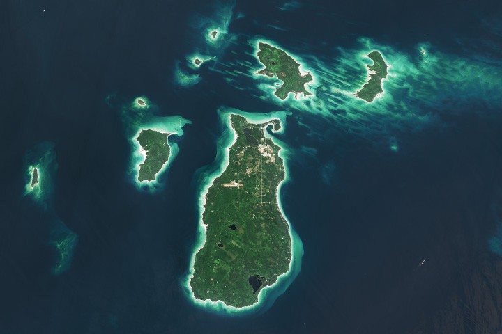
NASA’s Earth Observatory has published a new feature and accompanying Landsat 9 imagery of Beaver Island, the largest island in Lake Michigan. The report details the island’s geological origins, shaped over thousands of years by retreating ice sheets that carved distinct north-to-south ridges and valleys across the Great Lakes landscape. Erosion-resistant rock from these ridges remained above the water, forming the Beaver Archipelago.
The Landsat 9 Operational Land Imager captured the image on August 2, 2024, showing the island’s verdant upland forests, dunes, and wetlands. Beaver Island stretches 13 miles (21 kilometers) long and 6 miles (10 kilometers) wide, serving as the only inhabited island in the archipelago with a population of approximately 600 residents. Many of these residents are of Irish descent, a heritage that earned the island the nickname “America’s Emerald Isle” following the arrival of immigrants from County Donegal and Irish fishermen in the mid-1800s.
Historically, the island was a hub for farming and fishing. During the 1880s, it became the largest supplier of freshwater fish in the United States, though overfishing eventually reduced this abundance. The era also saw increased ship traffic on the Great Lakes, necessitating the construction of two lighthouses to assist vessels travelling between Chicago and the Straits of Mackinac. The Beaver Head Lighthouse operated from 1852 to 1962, while the Beaver Island Harbor Light, lit in 1870, remains an active beacon today.
Today, the island is a tourist destination accessible by boat or plane, offering activities such as biking, fishing, and kayaking. Its remote location and minimal light pollution contributed to its designation as the Beaver Island State Wildlife Research Area International Dark Sky Sanctuary in 2024. This status attracts sky gazers seeking to view the aurora borealis and other celestial phenomena.
The surrounding archipelago contains other distinct ecological features. High Island features cliff-top sand dunes up to 200 feet (60 meters) above lake level on its western side, home to unique plant species such as Pitcher’s thistle and Lake Huron tansy. Hog Island retains patches of old-growth northern hardwood forest. Wetland communities along the shorelines provide spawning grounds for perch and smallmouth bass, supporting the region’s rare plant and bird species.