Mexico City Sinking at Record Pace as NISAR Satellite Maps Ground Movement
Preliminary radar data from the NISAR satellite shows parts of the capital dropping more than half an inch per month, confirming historical trends with unprecedented precision.
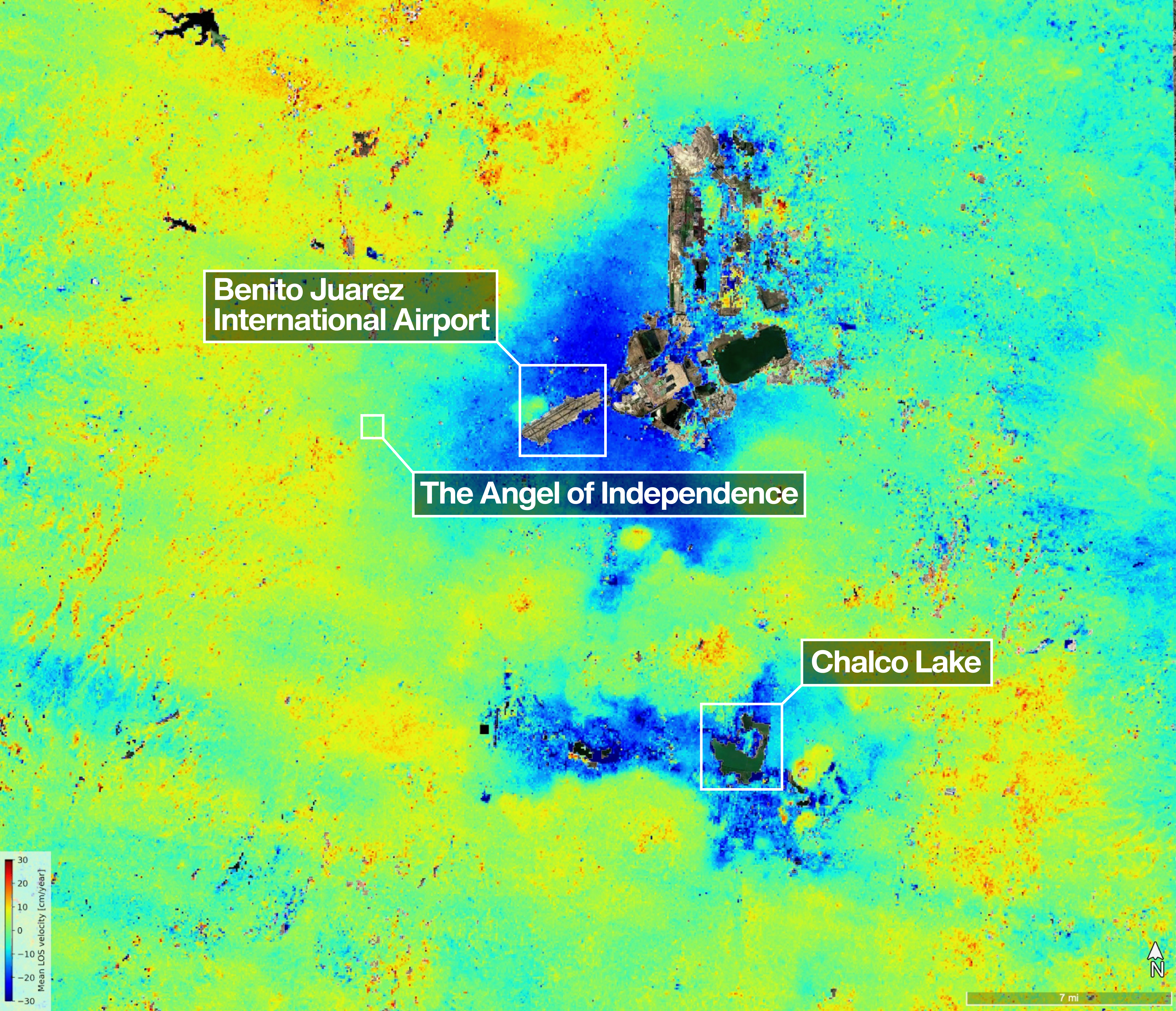
One of the most powerful radar systems ever launched into space has mapped the ground moving beneath Mexico City, one of the world's fastest-sinking capitals. The NISAR satellite, a collaborative mission between NASA and the Indian Space Research Organisation (ISRO), has used its L-band synthetic aperture radar to track real-time changes across the city's surface. This technology allows the satellite to monitor the terrain unhindered by clouds or vegetation, which often impede optical sensors and higher-frequency radars.
Preliminary measurements taken between October 2025 and January 2026 indicate that specific areas of the region are sinking at alarming rates. Analysis of the data collected during Mexico City's dry season shows parts of the area dropping by more than half an inch, or over two centimetres, per month. These findings confirm that the city's rapid downward movement, driven by extensive groundwater pumping and the structural weight of urban development, is detectable via the satellite even through dense vegetation.
The capital is built atop an ancient lakebed and aquifer, a geological reality that has complicated infrastructure for more than a century. An engineer first documented the issue in 1925, and by the 1990s and 2000s, parts of the metropolitan area were sinking by around 14 inches per year. This long-term compaction has damaged critical infrastructure, including the Metro, one of the largest rapid transit systems in the Americas. The new satellite data aligns with these historical expectations, providing a modern view of a persistent geological challenge.
The radar imagery clearly identifies the Angel of Independence as a visible indicator of this subsidence. Built in 1910 to commemorate 100 years of Mexico's independence, the towering monument stands 114 feet high and has historically required additional steps to be added to its base as the land around it gradually sank. The satellite data confirms that this landmark continues to settle, serving as a stark reminder of the ground's instability beneath the bustling metropolis.
Craig Ferguson, deputy project manager at NASA Headquarters in Washington, noted that images like this confirm the mission's measurements align with expectations for the region. He highlighted that NISAR's long wavelength L-band radar will make it possible to detect and track land subsidence in more challenging and densely vegetated regions. This capability is crucial for understanding compounding effects, such as those seen in coastal communities where land subsidence and sea level rise may interact.
The analysis distinguishes between actual subsidence signals, shown in dark blue on the imagery, and likely residual noise signals in yellow and red areas. These noise signals are expected to diminish as the mission collects more data, refining the accuracy of the maps. Managed by Caltech's Jet Propulsion Laboratory, the US component of the project provided the satellite's L-band SAR and antenna reflector, while ISRO supplied the spacecraft bus and S-band SAR.
David Bekaert, a member of the NISAR science team, stated that the mission will provide consistent global coverage to uncover new discoveries regarding land surface changes. Launched in July 2025, the spacecraft now advances efforts to analyse fast-changing areas that are difficult to survey from space. As the mission continues to pass overhead multiple times a month, it promises to deliver a comprehensive picture of how Earth's land and ice surfaces are evolving.


