Landslide-Induced Tsunami Strips Vegetation from Tracy Arm Fjord
Researchers publish new analysis of the August 2025 event in the journal *Science*, detailing how a tsunami stripped trees up to 481 metres above sea level.
On the morning of 10 August 2025, a catastrophic landslide triggered a tsunami within the Tracy Arm fjord in southeast Alaska. The event was driven by the rapid retreat of South Sawyer Glacier, which caused at least 64 million cubic metres of rock to slide downslope. The resulting wave stripped vegetation from the opposing fjord wall up to 481 metres above sea level and caused substantial destruction to shores and islands further down the waterway.
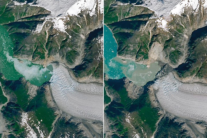
NASA-USGS Landsat satellites captured the landscape before and after the event, revealing a bright landslide scar on the north side of the fjord. The imagery also shows a distinct 'bathtub' ring where the forest was levelled, illustrating the immense reach of the water surge. Researchers noted that Sawyer Island, located about six miles from the landslide site, also turned from green to brown, with only a few trees remaining at higher elevations.
The seismic signals generated by the landslide were detected globally, equivalent to a magnitude 5.4 earthquake. In the months following the slide, a phenomenon known as a seiche, where water continued to slosh within the fjord, persisted for more than a day. The landslide also broke off a significant portion of the South Sawyer Glacier terminus, creating a slurry of icebergs in the fjord and exposing new areas of open water.
While no injuries were reported, the event did catch some by surprise. Kayakers camping on Harbor Island near the fjord's mouth had their gear swept away, and passengers aboard a small cruise vessel in neighbouring Endicott Arm reported swings in water levels and strong currents associated with the tsunami. The exact mechanisms that triggered the slide remain uncertain, though moderate rainfall prior to the event combined with rapid glacier retreat likely destabilised the slope.
A comprehensive analysis of the event was published in the journal *Science* on 6 May 2026. The study combined satellite, airborne, and ground-based observations with eyewitness reports and simulations to build a complete picture of how the event unfolded. The findings highlight that a glacier's shift from relative stability to renewed retreat, visible in satellite images, could serve as an important indicator that an area has become more susceptible to landslide and tsunami hazards.
The Tracy Arm fjord has been carved over millennia by the pressure and motion of glacial ice, yet the valley walls continue to be reshaped by such dramatic events. As the rapid retreat of glaciers exposes new areas of open water, the vulnerability of the landscape to landscape-reorganising tsunamis increases. This latest event serves as a stark reminder of the dynamic nature of the region and the ongoing changes driven by glacial dynamics.


