Landsat 9 turns to the Moon for monthly sensor checkup
While the Artemis programme captures public imagination, Landsat 9 relies on the Moon’s unchanging surface to calibrate its instruments and ensure the accuracy of decades-long climate records.
NASA’s Landsat 9 satellite performs a routine calibration check once every month during the full Moon phase, turning its instruments away from Earth to image the lunar surface. This process allows engineers to detect unintended sensor drift, ensuring that the data collected for Earth observation remains accurate and consistent over time. The Moon serves as a critical reference point because it is remarkably stable, lacking an atmosphere and experiencing virtually no surface changes, unlike the dynamic Earth below.
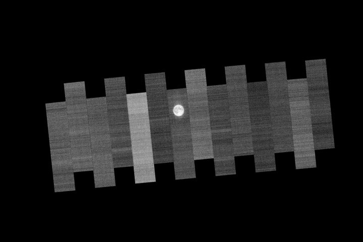
The calibration event described in recent NASA releases occurred on January 3, 2026, utilising band 4 of the Operational Land Imager (OLI) on Landsat 9. During this specific routine, the spacecraft maneuvers to image the Moon 15 times over the course of two orbits. The imaging process employs 14 detector modules within the instrument’s focal plane, with the satellite positioning itself so that each module captures the lunar surface, and one module capturing it twice to ensure comprehensive coverage.
This monthly checkup is part of a broader calibration strategy that has been essential to the NASA/USGS Landsat program since it began maintaining the longest continuous record of Earth’s land surface in 1972. The data collected is vital for tracking changes in crop health, glacial movement, habitats, tree species, and agricultural patterns. Without rigorous calibration, scientists could not confidently compare images acquired today with those from days, years, or decades ago.
In addition to lunar imaging, Landsat employs other methods to verify data integrity. The satellite also images uniform terrestrial surfaces, such as the White Sands desert in New Mexico, and compares its space-based measurements with ground-based data. For instance, scientists ensure that surface temperature readings recorded by Landsat’s thermal band match those taken on the ground. These efforts distinguish Landsat imagery from standard consumer photography, embedding crucial scientific information into every pixel.
The routine lunar calibration occurs against a backdrop of renewed interest in the Moon, with NASA’s Artemis programme recently taking humanity back to the lunar surface. While the Artemis missions focus on exploration, the data from Landsat 9 continues to provide a stable, long-term view of our home planet. By maintaining the integrity of its sensors through these monthly checks, the Landsat program ensures its data remains a reliable tool for understanding environmental changes on Earth.


