Japan Braces for Divergent Weather Patterns as Heat and Severe Storms Loom
NHK reports that a high-pressure system is driving summer-like heat across western and eastern Japan, while northern areas and the Kanto-Koshinetsu region face sudden weather deterioration, including lightning and tornadoes.
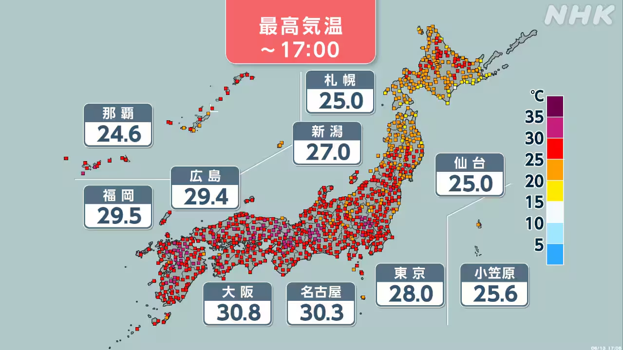
A high-pressure system is currently dominating the weather patterns across Japan, creating a stark contrast in conditions between the country’s southern and central regions and its northern territories. According to reports from NHK, the system is driving temperatures upward in western and eastern Japan, with some areas expected to experience "true summer days," defined as maximum temperatures reaching 30 degrees Celsius or higher.
Conversely, northern Japan and the Kanto-Koshinetsu region are facing significant instability due to the influence of upper-level cold air. Meteorological authorities have issued warnings for sudden weather changes in these areas, highlighting the risk of severe phenomena such as lightning, tornadoes, and violent gusts. The juxtaposition of high-pressure heat in the south and cold air aloft in the north has created a volatile atmospheric environment.
This current weather event follows a period of significant meteorological activity earlier in June 2026. On 3 June, the Japan Meteorological Agency (JMA) and the Tokyo Metropolitan Government issued a Level 4 flood danger warning for the Meguro River in Tokyo, indicating a high likelihood of flooding. Concurrently, an emergency safety assurance order was issued for households in southern prefectures as a linear rainband imminent prediction was activated for southern Tokushima, Wakayama, and Mie.
The current forecast for 13 June 2026 suggests that the high-pressure system affecting Honshu will continue to influence temperature readings across the western and eastern parts of the main island. While these regions prepare for summer heat, authorities in the north and central regions are monitoring the potential for rapid deterioration in weather conditions. The specific hazards identified for the Kanto-Koshinetsu and northern regions remain focused on convective storms and strong wind gusts.
Meteorological experts note that the definition of a "true summer day" is a key indicator of the seasonal shift occurring in the affected regions. As the high-pressure system persists, the disparity between the heat in the south and the instability in the north remains a critical focus for disaster preparedness and public safety communications.