Drought-Fueled Blazes in Southern Georgia Destroy Record Number of Homes
Extreme dryness and strong winds exacerbated the spread of the Pineland Road and Highway 82 fires, while NASA satellite imagery documents the devastation near Atkinson and Fruitland.
Firefighters are currently battling two destructive blazes in southern Georgia as an extreme drought grips the U.S. Southeast. The Pineland Road and Highway 82 fires together burned more than 50,000 acres as of 28 April, according to the Georgia Forestry Commission. This event has resulted in the destruction of more than 120 homes, the most lost to wildfire in the state's history.
The origins of the two blazes differ but were both human-caused. The Highway 82 blaze started on 18 April with a spark from a welding operation, while the Pineland Road fire ignited three days later after a mylar balloon collided with power lines. Both fires spread rapidly amid blustery winds in areas that were parched by months of limited rainfall.
Forestry officials note that fallen trees and limbs left by Hurricane Helene in September 2024 also helped fuel the fires. This event occurs amidst a broader trend of extreme fire activity across the U.S. Great Plains in March 2026, driven by dry, warm, and windy conditions.
Although heavy rains helped firefighters battle the blazes in recent days, containment remains a challenge. On 28 April, the Pineland Road fire remained 23 per cent contained and the Highway 82 fire 32 per cent contained. Hundreds of firefighting personnel are confronting the fires with equipment in the air and on the ground.
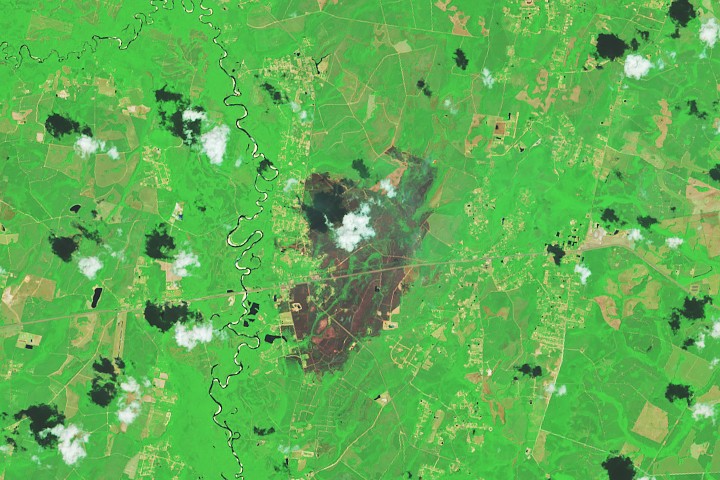
NASA satellite imagery captured by Landsat 8 documents the extent of the destruction, showing charred forests and residential areas in and around Atkinson and Fruitland. The images, which are false colour, reveal burned areas appearing gray against vegetated areas that remain green, with orange signatures indicating actively burning fire fronts.
NASA's satellite and aircraft data are part of a global system of observations used to track fire behaviour and support operational agencies in managing wildfires across the United States. Tools such as the Fire Information for Resource Management System and the Worldview browser provide real-time monitoring to assist in these critical efforts.


