Deadly Landslides Strike Papua New Guinea After Cyclone Maila Delivers Torrential Rains
Heavy precipitation saturated steep terrain in the Baining Mountains, triggering slope failures on 9 April 2026 and resulting in multiple fatalities.
Heavy rainfall from Tropical Cyclone Maila triggered deadly landslides in the Baining Mountains of East New Britain, Papua New Guinea, on or around 9 April 2026. The Category 4 storm lingered near Bougainville, New Britain, and New Ireland, saturating steep terrain and resulting in multiple fatalities. While tropical cyclones are relatively rare in the northern areas of the island nation due to the weak Coriolis effect near the equator, unusually warm sea surface temperatures and favourable atmospheric conditions allowed Maila to form and stall dangerously close to these islands in April 2026.
The storm was notable for its slow movement near Papua New Guinea, allowing rainbands to repeatedly strike East New Britain rather than passing quickly through the region. This prolonged exposure contributed to hundreds of millimetres of rain falling across the area in less than a week, according to satellite-based precipitation estimates from NASA's Global Precipitation Measurement (GPM) mission. The intense downpour saturated the steep terrain in the Gazelle district, leading to slope failures that caused significant loss of life.
NASA's Landslide Hazard Assessment for Situational Awareness (LHASA) model had previously identified parts of East New Britain, including the Baining Mountains, as having an elevated risk of slope failure during the height of the storm. The model uses precipitation estimates from GPM along with slope, soil, and land cover data to identify areas where rainfall is likely to trigger landslides. During the height of the storm, LHASA highlighted the region as being at high risk, underscoring the vulnerability of the landscape to the deluge.
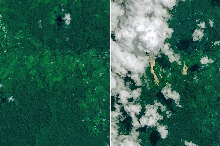
On 20 April 2026, NASA's Landsat 9 satellite captured imagery of the resulting landscape scars and sediment-laden waterways. The images show fresh landslide scars cutting through dense tropical forests, with the Toriu River and other waterways visible to the east carrying debris. The landslides appear as light-brown swaths of exposed soil and debris extending north toward a nearby river valley, contrasting sharply with the surrounding green vegetation and scattered white clouds.
A second image from Landsat 9 shows the same area on 24 September 2025, before the landslides occurred, providing a stark comparison of the terrain prior to the disaster. NASA Earth Observatory images were created by Michala Garrison using Landsat data from the U.S. Geological Survey. These visual records serve as a critical tool for monitoring the immediate impact of such extreme weather events on the ground.
Maila reached Category 4 strength on Australia's cyclone intensity scale, which corresponds to Category 3 on the Saffir-Simpson scale used for U.S. hurricanes. The combination of the storm's intensity and its slow progression created a perfect storm of conditions that overwhelmed the local environment. News reports confirm that the heavy rains saturated the steep terrain, triggering landslides on and around 9 April that led to several deaths.


