Ancient Martian Rocks Mapped in New 360-Degree Panorama by Perseverance Rover
NASA's Perseverance rover has assembled a natural-colour panorama from nearly a thousand images, marking a key transition before exploring the Lac de Charmes region later this year.
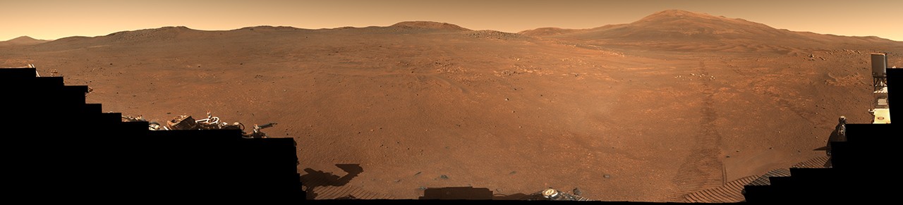
NASA's Perseverance Mars rover has completed a detailed survey of a geological feature on the rim of Jezero Crater, a region informally nicknamed "Crocodile Bridge". Using its Mastcam-Z camera system, the spacecraft has constructed a comprehensive 360-degree panorama that offers a natural-colour view of the ancient landscape. This visual record is composed of 980 individual images, processed to simulate how the terrain would appear to the human eye.
The data collection spanned a period of over a month, with the majority of the dataset captured on 18 December 2025. On that date, known as Sol 1,717 of the mission, the rover recorded 971 images of the area. A further nine images were taken on 25 January 2026, or Sol 1,754, to complete the full spherical view. These efforts have provided scientists with a high-resolution map of the site, which currently marks a transition zone to an area known as "Lac de Charmes", scheduled for exploration later in 2026.
The rocks exposed in this region are among the oldest in the solar system, acting as geological time capsules that preserve the history of Mars when its crust and atmosphere were first forming. Unlike Earth, where active tectonic plates constantly recycle surface material, Mars lacks such geological activity. This absence allows these very old materials to remain preserved on the surface, offering a unique window into the planet's deep past that no equivalent terrain exists on our own world.
The mission is managed by NASA's Jet Propulsion Laboratory (JPL) in Southern California, which was built and operates on behalf of the agency's Science Mission Directorate as part of the Mars Exploration Program portfolio. The specific Mastcam-Z instrument used for this survey is led by Arizona State University, with design and fabrication support provided by Malin Space Science Systems and the Niels Bohr Institute of the University of Copenhagen.
This latest imaging campaign follows the successful geological operations performed by previous missions, such as the Curiosity rover, which was also managed by JPL. The Perseverance rover continues to navigate the complex terrain of Jezero Crater, systematically documenting the environment as it prepares to move into the Lac de Charmes region for further study in the coming months.


